


ADTi 45MP 45PRO Surveyor Drone Mapping Cameras: The Latest Innovation For Drones
Presenting the ADTi 45MP 45PRO Surveyor Drone Mapping Camera System, designed for professional aerial mapping and surveying. The ADTi 45MP 45PRO offers precision and state-of-the-art technology, making it an ideal choice for surveyors in need of high-resolution, dependable, and efficient aerial mapping solutions.
ADTi 45MP 45PRO Surveyor Drone Mapping Cameras: Key Features
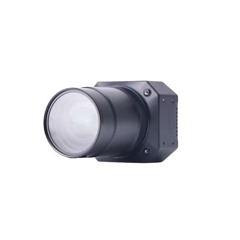
The ADTi 45PRO is equipped with an in-house designed 45 MP full-frame camera module, featuring the Sony IMX 366 back-illuminated sensor, which guarantees exceptional image clarity and detail. The camera system of the ADTi 45MP 45PRO Surveyor Mapping Drone is capable of capturing high-resolution images at 8192 x 5460 (45 MP, 3:2). Additionally, the Socionext Imaging processor, Milbeaut®, enhances the image quality while ensuring low heat generation.
ADTi 45MP 45PRO Surveyor Drone Mapping Cameras: Advanced Camera Specifications
- Full-frame Sony CMOS Sensor: 44.7 effective megapixels.
- Mechanical Shutter: Lightweight inter-mirror design with speeds ranging from 1/100 to 1/10000 seconds.
- Continuous Shooting: Capable of up to 2.0 frames per second with a minimum exposure interval of 0.5 seconds.
- Video Capture: Offers Full HD 1920×1080 resolution at 60p and 640×480 at 30p, outputting in MP4 format with an HDMI connection for live video streaming.
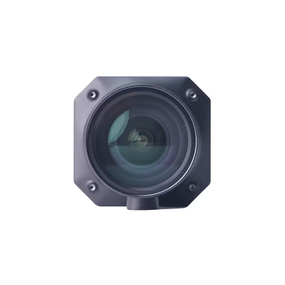
- Customizable Optics: ADTi provides a selection of fixed-focus lenses tailored for various mapping requirements:
21mm Fixed Lens: 92° diagonal field of view (FOV), distortion less than 0.3%, focus range from 50 meters to infinity.
40mm Fixed Lens: 57° diagonal FOV, distortion less than 0.037%, focus range from 50 meters to infinity.
56mm Fixed Lens: 42.2° diagonal FOV, distortion less than 0.3%, focus range from 50 meters to infinity. All lenses have a fixed aperture of F5.6, ensuring consistent performance across different mapping scenarios.
ADTi 45MP 45PRO Surveyor Drone Mapping Cameras: Integrated Functionality
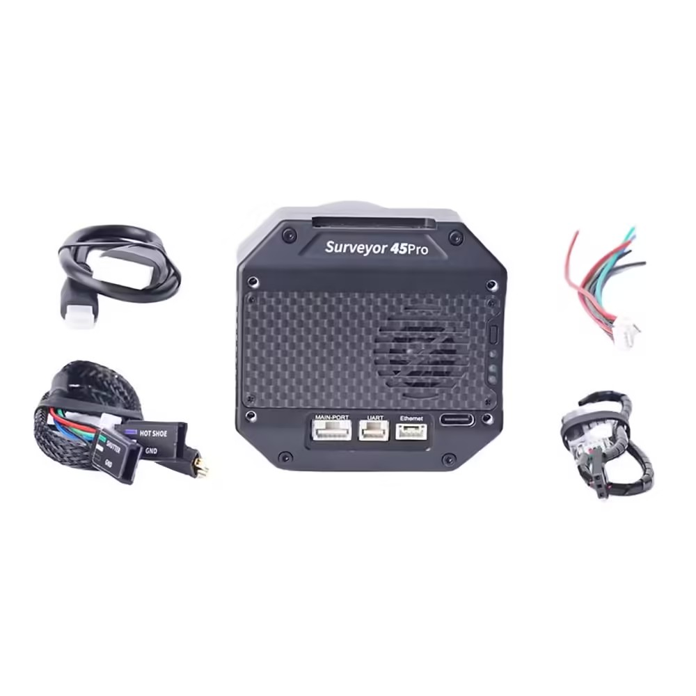
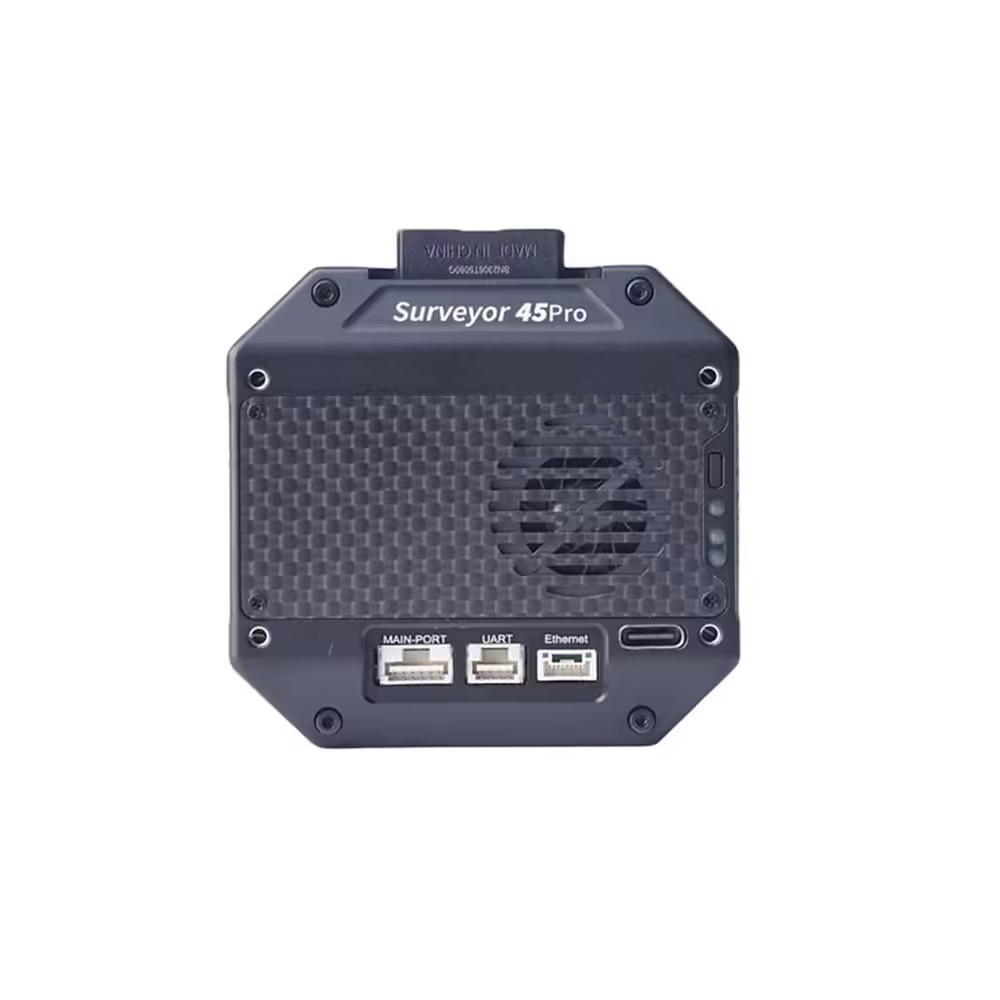
- Geo-Tagging and PPK Compatibility: Features a built-in multi-interface hot shoe for precise PPK (Post-Processing Kinematic) compatibility, as well as geo-tagging capabilities with Pixhawk flight controllers (requires ADTi POS&CTRL unit).
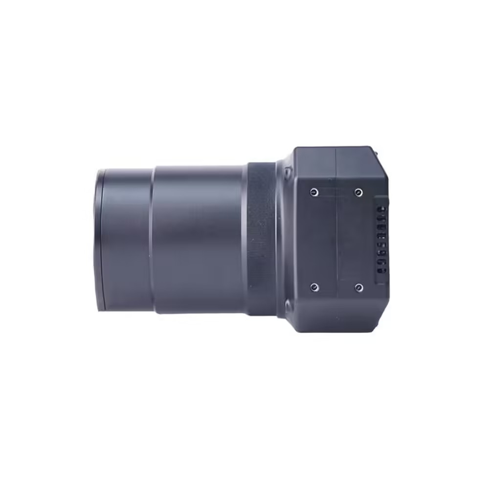
- Durable Design: The full aluminum construction ensures robustness and longevity.
- Connectivity: Includes an Ethernet port to facilitate real-time video streaming.
ADTi 45MP 45PRO Surveyor Drone Mapping Cameras: Efficient Power And Compact Design
- Power: Functions with 12-28V DC supplied by Lipo or Li-ion batteries.
- Compact and Lightweight: The camera has dimensions of 7.2 x 6.8 x 10.6 cm and a weight of 270 g when equipped with the 21mm lens, and 180 g with either the 40mm or 56mm lenses. The total weight of the package, including accessories, is 800 g.
ADTi 45MP 45PRO Surveyor Drone Mapping Cameras: Specifications And Overview
Image Sensor
- Type: CMOS, Sony IMX 366 back-illuminated
- Size: 876mm² (36.5 x 24mm)
- Pixel Size: 4.4 μm x 4.4 μm
- Aspect Ratio: 3:2
Image Capture
- Resolution: 8192 x 5460 (45 MP)
- File Format: JPEG
Shutter
- Type: Mechanical, replaceable
- Speed: 1/100 to 1/10000 seconds
- Continuous Mode: 2.0 frames/second
- Exposure Interval: ≥0.5s
Video Capture
- Resolution: 1920×1080 (60p), 640×480 (30p)
- File Format: MP4
- HD Output: HDMI
Lens Options
- 21mm: Manual fixed focus, FOV 92°, aperture F5.6
- 40mm: Manual fixed focus, FOV 57°, aperture F5.6
- 56mm: Manual fixed focus, FOV 42.2°, aperture F5.6
Camera Dimensions and Weight
- Size: 7.2 x 6.8 x 10.6 cm
- Weight: 270g (21mm lens), 180g (40mm or 56mm lens)
- Package Size: 14.5 x 10 x 6 cm
- Package Weight: 800g
- Operating Temperature: -10 to 40 °C
ADTi 45MP 45PRO Surveyor Drone Mapping Cameras: Unmatched Utility And Versatility
The ADTi 45MP 45PRO Drone Mapping Camera System transcends a mere camera; it is a complete solution tailored for the ADTi 45MP 45PRO Surveyor Mapping Drones. It serves a multitude of professional needs, ranging from land surveying and geospatial mapping to infrastructure inspection and environmental monitoring. The ADTi 45MP 45PRO Surveyor Aerial Mapping Cameras are versatile, catering to various requirements with ease. Equipped with high-resolution capabilities, they enable precise and detailed data collection, proving to be an essential tool for surveyors and mapping professionals.
ADTi 45MP 45PRO Surveyor Drone Mapping Cameras: Enhanced Surveying Efficiency
The 45MP Drone Camera for Mapping features advanced geo-tagging and PPK capabilities. The ADTi 45MP 45PRO significantly cuts down the time and effort needed for post-processing, allowing for the swift and efficient delivery of precise, geo-referenced data. Its compatibility with Pixhawk flight controllers ensures seamless and trouble-free integration into existing drone systems, further improving operational efficiency.
ADTi 45MP 45PRO Surveyor Drone Mapping Cameras: Built For Durability And Performance
The 45MP Drone Camera for Mapping is built to endure the demands of fieldwork, featuring a durable full aluminum structure. Its robust construction guarantees reliability in even the most challenging conditions, while its lightweight design ensures minimal impact on drone flight performance. Additionally, the camera is equipped with an Ethernet port, enhancing its functionality by enabling live video streaming for simplified real-time monitoring and adjustments during flight operations.
ADTi 45MP 45PRO Surveyor Drone Mapping Cameras: Commercial Viability
Ideal for businesses and professionals in the surveying and mapping sectors, this Aerial Mapping Drone Camera provides a substantial return on investment. Equipped with high-resolution imaging and enhanced by features such as direct geo-tagging and PPK compatibility, it enables quicker completion of projects with greater precision. This efficiency not only lowers operational expenses but also improves the quality of service offered to clients.
ADTi 45MP 45PRO Surveyor Drone Mapping Cameras
The ADTi 45MP 45PRO Surveyor Drone Mapping Camera System is an essential tool for surveyors and mapping professionals, combining advanced imaging technology with customizable optics and a robust design. It delivers unparalleled performance in aerial mapping and surveying tasks. Known for its exceptional image quality, integrated functionality, and durable construction, the ADTi 45MP 45PRO Surveyor Drone Mapping Camera is the preferred choice for precision in aerial mapping projects. Step into the future of surveying with the ADTi 45MP 45PRO and take your projects to the next level.
Package Include.
1 X ADTi 45MP 45PRO Surveyor Drone Mapping Cameras.
Related Products
- ADTi 61MP 61S Surveyor Drone Mapping Cameras
- 2-Axis Brushless Gimbal Controller Board
- ADTi 20MP 20L V1 APS-C Drone Mapping Cameras
ADTi 45MP 45PRO Surveyor Drone Mapping Cameras Overview
The ADTi 45MP 45PRO is a professional-grade aerial mapping camera system designed for precise, high-resolution drone surveys. Equipped with a full-frame Sony back-illuminated sensor and a mechanical shutter, it captures detailed 45 MP images ideal for surveying, mapping, and inspection tasks.
Key Features of ADTi 45MP 45PRO Surveyor Drone Mapping Cameras
- 44.7 effective megapixels from a full-frame Sony IMX366 back-illuminated CMOS sensor
- Mechanical inter-mirror shutter with speeds ranging from 1/100 to 1/10000 seconds
- Continuous shooting up to 2.0 frames per second with a ≥0.5 s exposure interval
- High-resolution output at 8192 × 5460 pixels in 3:2 aspect ratio
- Lightweight, compact design optimized for professional drone gimbals
- Fast shipping from Zbotic ensuring delivery within 24 hours (in-stock items)
Applications and Use Cases
- Topographic and cadastral mapping for land surveyors
- Precision agriculture crop health analysis
- Infrastructure inspection of roads, bridges, and pipelines
- Urban planning and construction site monitoring
- Environmental and forestry canopy studies
- Disaster assessment and terrain modeling
How to Use ADTi 45MP 45PRO Surveyor Drone Mapping Cameras
Install the ADTi 45MP 45PRO on a compatible drone gimbal, connect its power and data interfaces to your flight controller, and configure exposure and shutter settings in your mapping software. Plan your flight mission to define waypoints and overlap, then initiate the flight to capture geotagged high-resolution images for post-processing and orthomosaic generation.
Why Buy from Zbotic?
- Genuine Products: All items sourced from authorized distributors
- Fast Shipping: Orders ship within 24 hours with tracking (non backordered products)
- Free Shipping: Free delivery on qualifying orders
- COD Available: Cash on Delivery, UPI, cards, net banking
- Technical Support: Expert help for setup and troubleshooting
- Easy Returns: Hassle-free replacement for defective products
Frequently Asked Questions
What resolution and sensor does the ADTi 45MP 45PRO use?
It features a Sony IMX366 back-illuminated full-frame CMOS sensor capturing images at 8192 × 5460 pixels, delivering 45 MP of detail.
How fast can the camera shoot continuously?
The mechanical inter-mirror shutter enables continuous shooting up to 2.0 frames per second, with a minimum exposure interval of 0.5 seconds for rapid capture.
How do I integrate the ADTi 45PRO into my drone?
Mount the camera on a compatible drone gimbal, connect power and data cables to your flight controller, configure settings in your mapping software, then execute your pre-planned flight mission to collect geotagged imagery.

FPV Drone Range Extender: Booster Amplifiers for Video TX Explained
Table of ContentsUnderstanding FPV Video Range LimitationsHow Video TX Booster Amplifiers WorkTypes of Range Extension SolutionsAntenna Selection for...
Read More →
Drone Build Troubleshooting: Common First-Build Mistakes
Every drone builder faces setbacks during their first build, and effective drone build troubleshooting is a skill that...
Read More →
Indian Airspace Zones: Where Can You Fly Your Drone
Understanding Indian airspace zones for drone flying is fundamental for every drone pilot, whether you are flying recreationally...
Read More →Technical Specifications
| Brand | ADTi |
|---|---|
| SKU | AI6061 |
| Availability | In Stock |
Applications & Use Cases
The ADTi 45MP 45PRO Surveyor Drone Mapping Cameras is a versatile drone gimbal and accessories used across a wide range of applications including electronics projects, DIY builds, prototyping, and educational experiments.
Common use cases:
- Integrating into a custom electronics project
- Learning and experimenting with circuits
- Replacing or upgrading components in existing setups
This product is ideal for electronics enthusiasts, engineers, and students.
Technical Tip: Always verify voltage and current requirements before connecting to your circuit. Check datasheets for detailed specifications and pin configurations.
Shipping & Delivery
- Free shipping on orders above ₹999 across India
- Dispatched within 1-3 business days
- Expected delivery: 3-7 business days depending on location
- Secure packaging to ensure safe transit of electronic components
- Genuine ADTi product sourced from authorized channels


Kiara Bajaj (verified owner) –
Very impressed with this ADTi 45MP 45PRO Surveyor Drone Mapping. My drone’s performance improved noticeably.
Sneha Kulkarni (verified owner) –
Okay ADTi 45MP 45PRO Surveyor Drone Mapping. Gets the job done for my basic drone project. Nothing exceptional.
Sonali Singh (verified owner) –
Received the ADTi 45MP 45PRO Surveyor Drone Mapping in great condition. Testing done, everything works perfectly.
Sandhya Goyal (verified owner) –
Received the ADTi 45MP 45PRO Surveyor Drone Mapping in great condition. Testing done, everything works perfectly.
Swati Chatterjee –
Average ADTi 45MP 45PRO Surveyor Drone Mapping. Works fine but expected slightly better quality at this price.
Lakshmi Dave –
Using this ADTi 45MP 45PRO Surveyor Drone Mapping in my hexacopter. Smooth operation and excellent thrust.
Isha Desai (verified owner) –
Bought this for my college drone project. Works great, professor was impressed!
Kabir Thakur (verified owner) –
Decent ADTi 45MP 45PRO Surveyor Drone Mapping for the price. Using it in my quadcopter, performs well overall.
Pooja Sen (verified owner) –
Solid ADTi 45MP 45PRO Surveyor Drone Mapping. Not the absolute best but excellent value for the price point.
Sahil Negi –
Bought this for my college drone project. Works great, professor was impressed!
Bhavna Vohra (verified owner) –
Great ADTi 45MP 45PRO Surveyor Drone Mapping for beginners and professionals alike. Highly recommended for drone enthusiasts.
Jatin Choudhury (verified owner) –
Decent ADTi 45MP 45PRO Surveyor Drone Mapping for the price. Using it in my quadcopter, performs well overall.
Vishal Thakur (verified owner) –
This ADTi 45MP 45PRO Surveyor Drone Mapping is value for money. Comparing with other brands, Zbotic offers the best deal.
Anand Dave –
Been using this ADTi 45MP 45PRO Surveyor Drone Mapping for 3 months now, zero issues. Great product.
Anjali Menon (verified owner) –
This ADTi 45MP 45PRO Surveyor Drone Mapping is exactly what I needed for my drone. Works perfectly, very reliable.
Vishal Verma –
Great quality ADTi 45MP 45PRO Surveyor Drone Mapping. Perfect specs for my drone project. Fast delivery too!
Bharat Modi (verified owner) –
This ADTi 45MP 45PRO Surveyor Drone Mapping is value for money. Comparing with other brands, Zbotic offers the best deal.
Tejas Iyer (verified owner) –
Great ADTi 45MP 45PRO Surveyor Drone Mapping for beginners and professionals alike. Highly recommended for drone enthusiasts.
Shubham Goyal –
Excellent ADTi 45MP 45PRO Surveyor Drone Mapping! Perfect for my quadcopter build. Arrived well packed and works flawlessly.
Anil Shetty (verified owner) –
My 5th order from Zbotic. This ADTi 45MP 45PRO Surveyor Drone Mapping is excellent as always. Totally reliable store.
Lalit Mittal –
Using this ADTi 45MP 45PRO Surveyor Drone Mapping in my hexacopter. Smooth operation and excellent thrust.
Bharat Sen (verified owner) –
Excellent ADTi 45MP 45PRO Surveyor Drone Mapping! Perfect for my quadcopter build. Arrived well packed and works flawlessly.