


ADTi 24MP 24S V3 Surveyor Lite Drone Mapping Cameras: Call Us To Buy This Product
Introducing the ADTi 24MP 24S V3 Surveyor Lite Drone Mapping Cameras. The fourth generation in ADTi’s line of esteemed 24MP APS-C Drone/UAV Mapping Cameras, the ADTi 24MP 24S V3 Surveyor Lite Aerial Mapping Cameras are crafted with state-of-the-art technology. This model features the ADTi SDK camera control system, which is fully compatible with Airpixel for PIX4 and Ardupilot MAVlink, rendering it an essential instrument for professional aerial mapping and surveying tasks.
ADTi 24MP 24S V3 Surveyor Lite Drone Mapping Cameras: Key Features & Specifications
- Enhanced Shutter Speed: The ADTi 24MP 24S V3 Surveyor Lite UAV Mapping Systems boast a shutter speed that is double that of its predecessors, the 24L V1, V2, and 24S V2, making them perfect for fixed-wing UAVs that require both speed and precision.
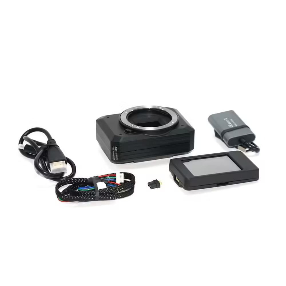
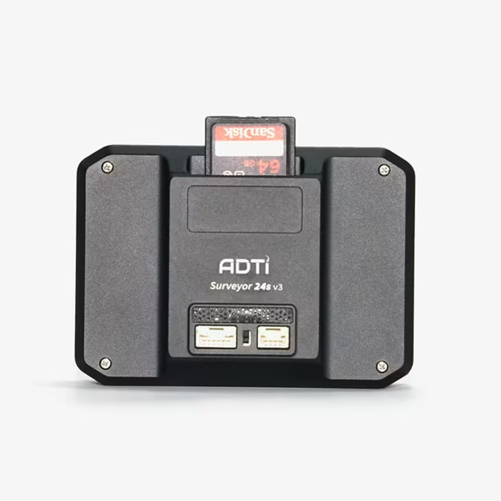
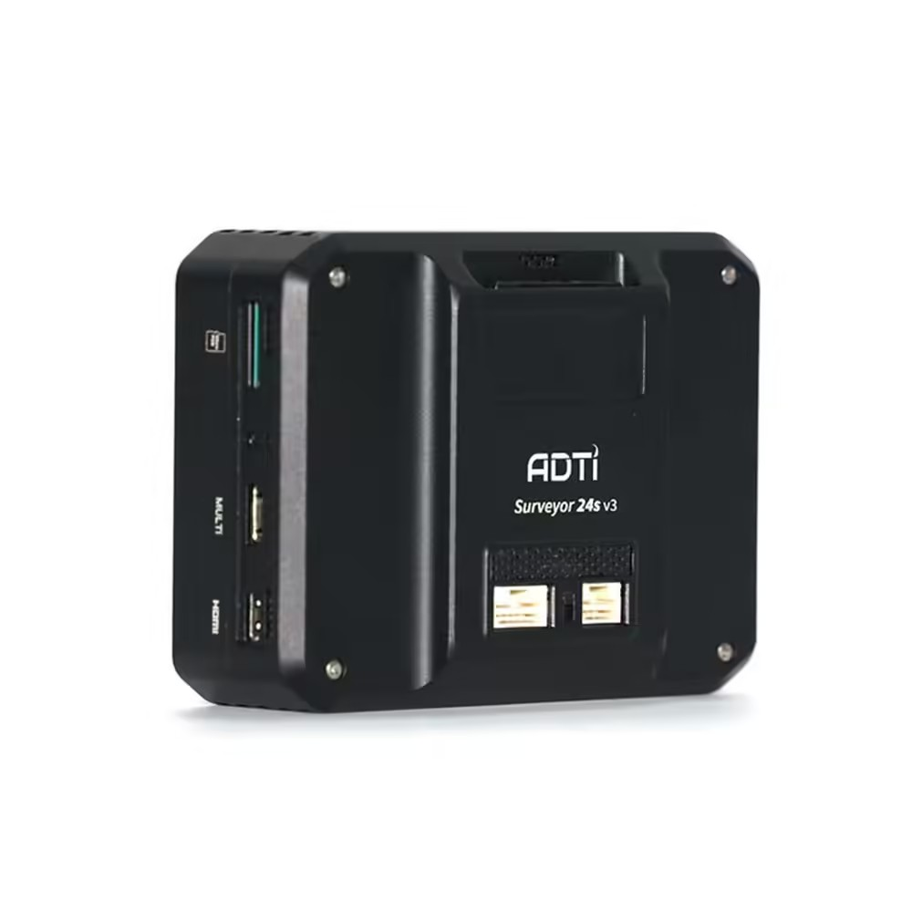
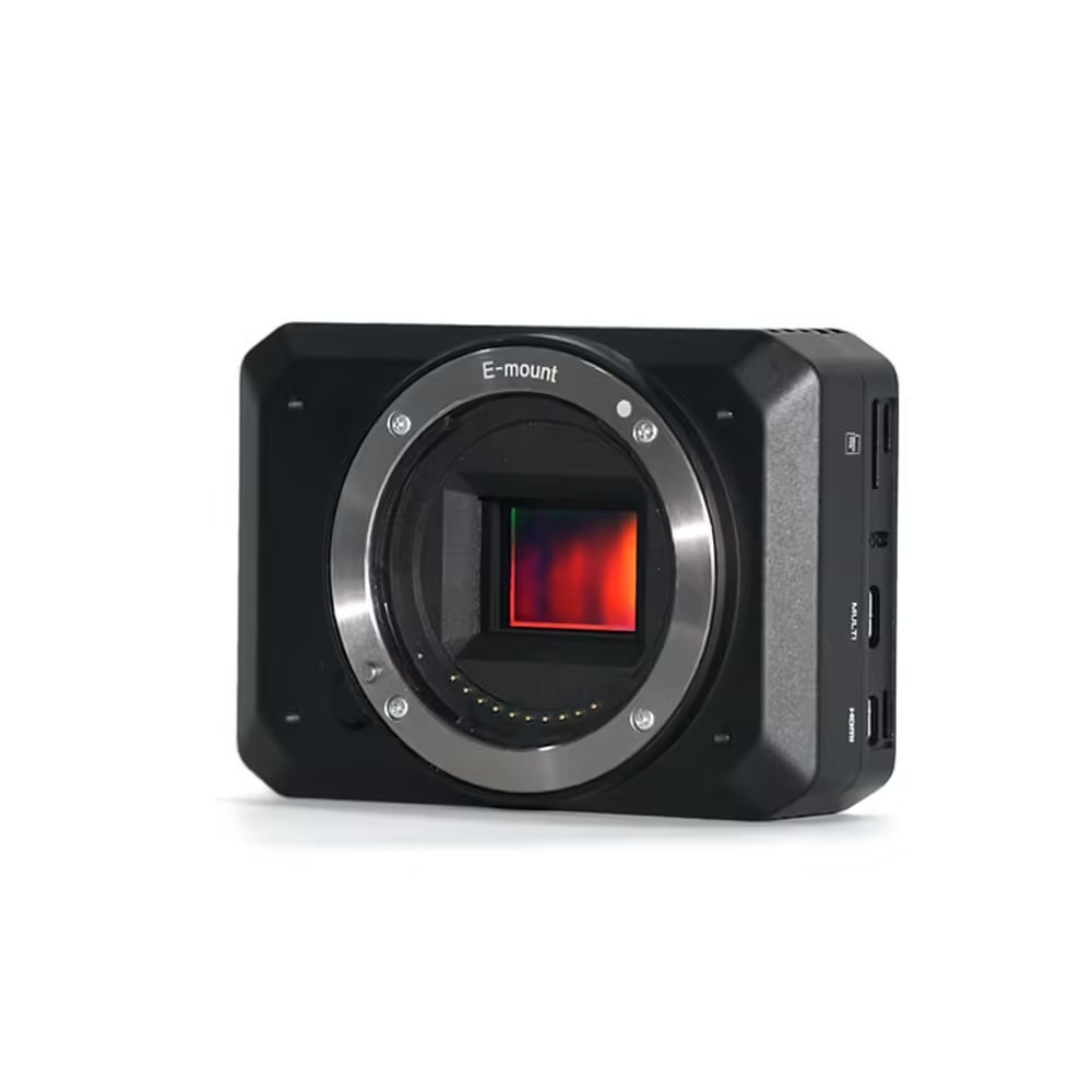
- Intuitive Interface: Equipped with a serial mini touchscreen for straightforward camera configuration and an HDMI video capture card, the ADTi 24MP 24S V3 Surveyor Lite Precision Mapping Drones camera connects to any Android device for live settings monitoring.
- Flexible Triggering Options: Offering TTL or PWM triggering options via a switch button, the ADTi 24MP 24S V3 Surveyor Lite Topographic Drone Cameras are versatile for a range of applications.
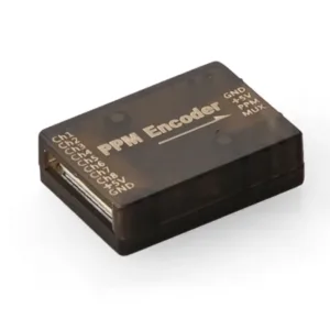
- Compact and Lightweight: The ADTi 24MP 24S V3 Surveyor Lite Cartographic UAV Cameras, at just 143 g and dimensions of 89.8*63*36.2 mm, are built for easy integration and minimal impact on drone payload capacity.
- Sturdy Construction: Encased in a durable aluminum housing, these cameras are built to withstand tough conditions.
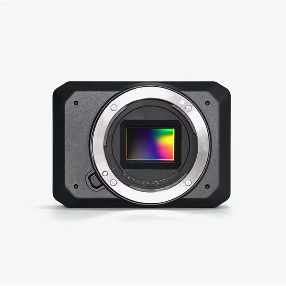
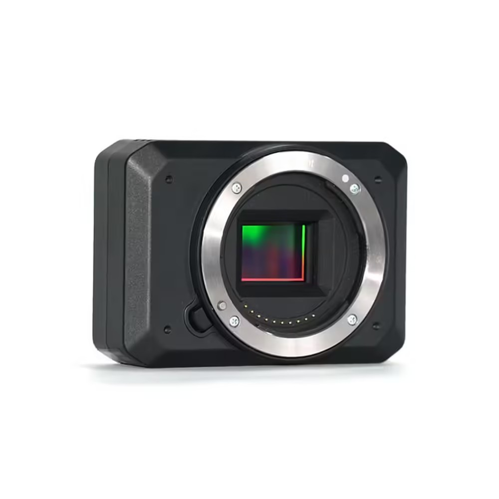
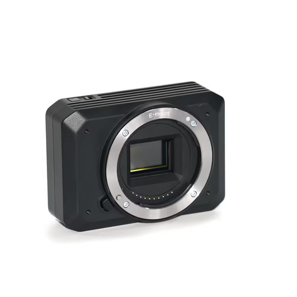
- Superior Resolution: With a 24MP APS-C sensor, these cameras deliver high-resolution images ideal for professional-level mapping.
ADTi 24MP 24S V3 Surveyor Lite Drone Mapping Cameras: Compatibility
- Geotagging is compatible with Airpixel R3 for accurate geotagging. The system integrates smoothly with Gremsy Mio 2-Axis and Mio 3-Axis camera gimbals, as well as the ADTi 2-Axis nadir fixed-wing gimbal. It supports ADTi lightweight lenses, including 16mm APS-C, 25mm APS-C, 35mm APS-C, 40mm FF, 18mm FF, 50mm FF, and 56mm FF.
ADTi 24MP 24S V3 Surveyor Lite Drone Mapping Cameras: Other Features
Image Sensor:
- Type: CMOS
- Manufacturer: Sony
- Effective Megapixels: 24.3
- Format: APS-C
- Size: 366.6mm² (23.50mm x 15.60mm)
- Pixel Pitch: 3.92 microns
- Aspect Ratio: 3:2
- Color Filter Type: RGBG
- Anti-Aliasing Filter: Fixed
- Color Depth: 24.1 bits
- Maximum Effective ISO: 1,347
Image Capture:
- Resolutions:
-
- 6000 x 4000 (24.0 MP, 3:2)
- 6000 x 3376 (20.3 MP, 16:9)
- 4240 x 2832 (12.0 MP, 3:2)
- 4240 x 2400 (10.2 MP, Other)
- 3008 x 2000 (6.0 MP, 3:2)
- 3008 x 1688 (5.1 MP, 16:9)
- 12416 x 1856 (23.0 MP, Other)
- 8192 x 1856 (15.2 MP, Other)
- 2160 x 5536 (12.0 MP, Other)
- 2160 x 3872 (8.4 MP, Other)
- File Formats: JPEG, RAW, RAW+JPEG
- Continuous-mode: Up to 11.1 frames per second
Video Capture:
- Resolutions:
-
- 1920×1080 (60p/60i/30p/24p)
- 1440×1080 (30p)
- 640×480 (30p)
- File Formats: XAVC S/AVCHD 2.0 / MP4
- HD Video Out: Yes
- Connection: HDMI
Lens & Optics:
- Mount: Sony E
- Focus Range: 25 cm to Infinity
- Auto Focus: Yes
- Manual Focus: Yes
Display (Detached):
- Power: 5V DC
- Screen Size: 2 inch mini touch screen
Camera Dimensions and Power:
- Size: 8.9*6.3*3.6 cm
- Weight: 133 g
- Package Size: 302015 cm
- Package Weight: 500 g
- Power Supply: 10-25V DC Lipo or Liion
- Operating Temperature: -10 to 40 °C
ADTi 24MP 24S V3 Surveyor Lite Drone Mapping Cameras: Stocks Are Running Out! Buy Now
The ADTi 24MP 24S V3 Surveyor Lite Drone Mapping Cameras redefine aerial mapping with their exceptional speed, accuracy, and user-friendliness. Ideal for professional surveying or sophisticated geospatial tasks, these cameras are the definitive choice for securing top-notch outcomes.
Package Include.
1 X ADTi 24MP 24S V3 Surveyor Lite Drone Mapping Cameras.
ADTi 24MP 24S V3 Surveyor Lite Drone Mapping Cameras Overview
The ADTi 24MP 24S V3 Surveyor Lite is a fourth-generation aerial mapping camera built around a Sony 24.3 MP APS-C CMOS sensor (23.50 × 15.60 mm). Designed for UAV and drone survey missions, it delivers high-resolution imagery with an enhanced shutter system and integrates seamlessly via the ADTi SDK with Airpixel for PIX4 and Ardupilot MAVlink flight controllers.
Key Features of ADTi 24MP 24S V3 Surveyor Lite Drone Mapping Cameras
- 24.3 Megapixel Sony APS-C CMOS sensor (366.6 mm²) for crisp, detailed aerial imagery
- Enhanced electronic shutter speed, twice as fast as previous Surveyor Lite models
- ADTi SDK camera control fully compatible with Airpixel for PIX4 and Ardupilot MAVlink
- Compact, lightweight design optimized for UAV integration and extended flight times
- Precision geotagging and frame synchronization for accurate photogrammetric workflows
- Genuine product guaranteed by Zbotic with fast shipping across India
Applications and Use Cases
- Topographic mapping and digital elevation model (DEM) generation
- Orthomosaic creation for land use planning and surveying
- Precision agriculture monitoring of crop health and biomass indices
- Construction site progress documentation and volumetric analysis
- Environmental and forestry surveys, including canopy height and biomass studies
- Infrastructure inspection—roads, bridges, pipelines—using high-resolution aerial photos
How to Use ADTi 24MP 24S V3 Surveyor Lite Drone Mapping Cameras
To set up the Surveyor Lite, mount the camera securely on your drone’s gimbal, connect its data and power cables to the flight controller, and install the ADTi SDK plugin. Calibrate the gimbal and verify communication via Airpixel for PIX4 or Ardupilot MAVlink. Plan your flight path in your preferred mission software, trigger the shutter either automatically through the SDK commands or manually via the ground station, then download images after landing for photogrammetric processing.
Why Buy from Zbotic?
- Genuine Products: All items sourced from authorized distributors
- Fast Shipping: Orders ship within 24 hours with tracking (non backordered products)
- Free Shipping: Free delivery on qualifying orders
- COD Available: Cash on Delivery, UPI, cards, net banking
- Technical Support: Expert help for setup and troubleshooting
- Easy Returns: Hassle-free replacement for defective products
Frequently Asked Questions
Which flight controllers are compatible with the Surveyor Lite camera?
The ADTi 24MP 24S V3 integrates seamlessly with Pixhawk-based systems using Ardupilot MAVlink and PX4 via Airpixel for PIX4, allowing for automated shutter triggers and precise geotag synchronization.
How does the enhanced shutter speed improve aerial mapping?
This model’s electronic shutter operates at twice the speed of the previous generation, reducing motion blur during high-velocity passes and ensuring sharper images when the drone is in rapid or windy flight conditions.
Can I trigger the camera manually during flight?
Yes. You can trigger the shutter manually from your ground station software through the ADTi SDK commands or automate image capture as part of a pre-planned mission in Pix4D, DroneDeploy or similar photogrammetry platforms.

Hexacopter Build: Heavy Lift Drone for Payloads
Table of Contents Understanding Hexacopter Build Key Components and Requirements Step-by-Step Setup Guide Configuration and Optimisation Practical Tips...
Read More →
3-Inch Toothpick FPV Drone Build: Ultra-Light Indoor Flier
3-Inch Toothpick FPV Drone Build: Ultra-Light Indoor Flier The 3-inch toothpick FPV drone is one of the most...
Read More →
FPV Goggle Buying Guide 2026: DJI Goggles vs Walksnail
Table of Contents Why Your FPV Goggles Matter More Than Your Drone Analog vs Digital FPV in 2026...
Read More →Technical Specifications
| Brand | ADTi |
|---|---|
| SKU | AI6068 |
| Weight | 0.351 kg |
| Availability | In Stock |
Applications & Use Cases
The ADTi 24MP 24S V3 Surveyor Lite Drone Mapping Cameras is a versatile drone gimbal and accessories used across a wide range of applications including electronics projects, DIY builds, prototyping, and educational experiments.
Common use cases:
- Integrating into a custom electronics project
- Learning and experimenting with circuits
- Replacing or upgrading components in existing setups
This product is ideal for electronics enthusiasts, engineers, and students.
Technical Tip: Always verify voltage and current requirements before connecting to your circuit. Check datasheets for detailed specifications and pin configurations.
Shipping & Delivery
- Free shipping on orders above ₹999 across India
- Dispatched within 1-3 business days
- Expected delivery: 3-7 business days depending on location
- Secure packaging to ensure safe transit of electronic components
- Genuine ADTi product sourced from authorized channels


Kunal Das (verified owner) –
Using this ADTi 24MP 24S V3 Surveyor Lite in my FPV drone build. Quality is top notch. Very happy with the purchase.
Vijay Joshi (verified owner) –
Amazing build quality! This ADTi 24MP 24S V3 Surveyor Lite is sturdy and lightweight at the same time.
Rahul Kulkarni (verified owner) –
Very impressed with this ADTi 24MP 24S V3 Surveyor Lite. My drone’s performance improved noticeably.
Ishaan Garg –
Outstanding ADTi 24MP 24S V3 Surveyor Lite! Installed it on my racing quad and the performance is amazing.
Kavya Thakur (verified owner) –
Good ADTi 24MP 24S V3 Surveyor Lite. Works well for my drone build. Packaging could be slightly better.
Devansh Agarwal (verified owner) –
Top quality ADTi 24MP 24S V3 Surveyor Lite. I’m a regular customer of Zbotic and they never disappoint.
Piyush Rao –
Great quality ADTi 24MP 24S V3 Surveyor Lite. Perfect specs for my drone project. Fast delivery too!
Darshan Nayak (verified owner) –
Pretty good ADTi 24MP 24S V3 Surveyor Lite. Works as expected for my drone project. Would buy again.
Prashant Srivastava (verified owner) –
Good quality ADTi 24MP 24S V3 Surveyor Lite. Minor scratches on arrival but functionally perfect.
Divyansh Khurana (verified owner) –
Decent ADTi 24MP 24S V3 Surveyor Lite for the price. Using it in my quadcopter, performs well overall.
Darshan Tiwari (verified owner) –
Excellent ADTi 24MP 24S V3 Surveyor Lite! Perfect for my quadcopter build. Arrived well packed and works flawlessly.
Sanjay Bhandari (verified owner) –
Nice ADTi 24MP 24S V3 Surveyor Lite, does the job. Delivery took a couple of extra days but product is solid.
Arjun Bhandari –
Pretty good ADTi 24MP 24S V3 Surveyor Lite. Works as expected for my drone project. Would buy again.
Tanya Khurana (verified owner) –
Solid ADTi 24MP 24S V3 Surveyor Lite. Not the absolute best but excellent value for the price point.
Milan Bose (verified owner) –
Using this ADTi 24MP 24S V3 Surveyor Lite in my FPV drone build. Quality is top notch. Very happy with the purchase.
Ananya Panchal (verified owner) –
Very impressed with this ADTi 24MP 24S V3 Surveyor Lite. My drone’s performance improved noticeably.
Siddharth Chauhan (verified owner) –
Using this ADTi 24MP 24S V3 Surveyor Lite in my FPV drone build. Quality is top notch. Very happy with the purchase.
Rohan Menon –
This ADTi 24MP 24S V3 Surveyor Lite is value for money. Comparing with other brands, Zbotic offers the best deal.
Shivam Srivastava –
Good ADTi 24MP 24S V3 Surveyor Lite. Works well for my drone build. Packaging could be slightly better.
Utkarsh Goyal (verified owner) –
Okay ADTi 24MP 24S V3 Surveyor Lite. Gets the job done for my basic drone project. Nothing exceptional.
Ishaan Vyas (verified owner) –
Great quality ADTi 24MP 24S V3 Surveyor Lite. Perfect specs for my drone project. Fast delivery too!
Vipin Parekh (verified owner) –
Decent ADTi 24MP 24S V3 Surveyor Lite for the price. Using it in my quadcopter, performs well overall.
Yogesh Vohra –
Excellent ADTi 24MP 24S V3 Surveyor Lite! Perfect for my quadcopter build. Arrived well packed and works flawlessly.
Aanya Grewal (verified owner) –
Outstanding ADTi 24MP 24S V3 Surveyor Lite! Installed it on my racing quad and the performance is amazing.
Kavya Iyer (verified owner) –
Nice ADTi 24MP 24S V3 Surveyor Lite, does the job. Delivery took a couple of extra days but product is solid.
Dev Jain (verified owner) –
Using this ADTi 24MP 24S V3 Surveyor Lite in my FPV drone build. Quality is top notch. Very happy with the purchase.
Nikhil Kumar (verified owner) –
Been using this ADTi 24MP 24S V3 Surveyor Lite for 3 months now, zero issues. Great product.