
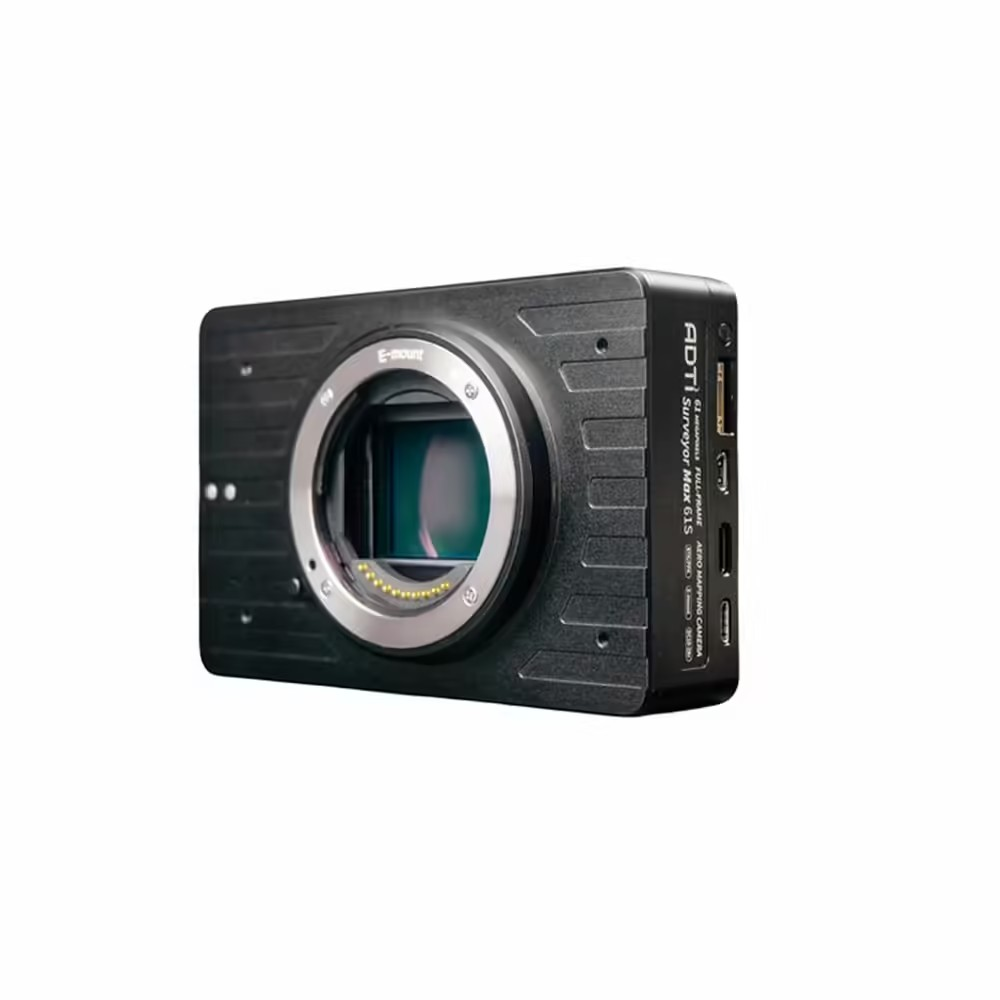


ADTi 61MP 61S Surveyor Drone Mapping Cameras
Presenting the ADTi 61MP 61S Surveyor Drone Mapping Cameras – a high-resolution imaging solution tailored for professional aerial mapping and surveying tasks. This sophisticated 61MP Drone Camera merges state-of-the-art technology with durable performance, establishing itself as a vital instrument for surveyors, cartographers, and mapping experts.
ADTi 61MP 61S Surveyor Drone Mapping Cameras: Key Features
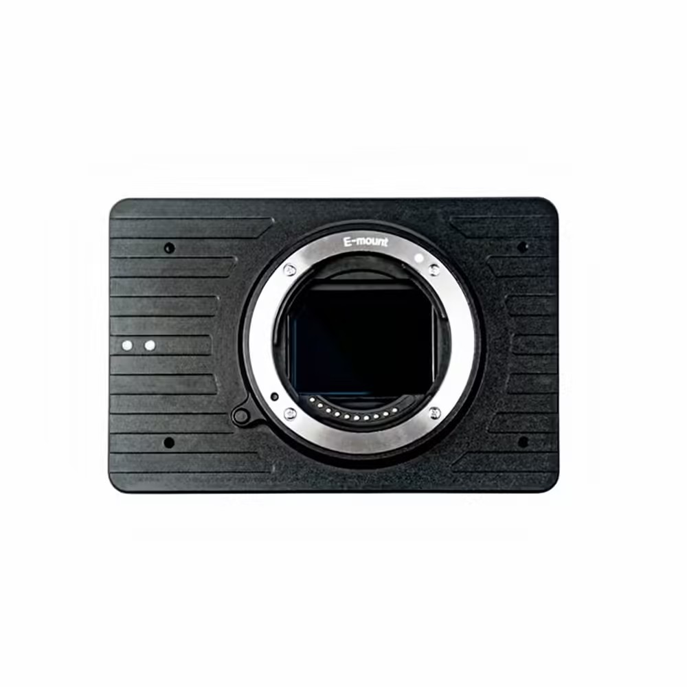
- 61 Megapixel Full-Frame Sony CMOS Sensor: With the high-resolution 61MP full-frame Sony CMOS sensor, capture every detail with remarkable clarity and precision.
- E-Mount Full-Frame Lens Compatibility: Offers the flexibility to use any E-mount full-frame lenses, including the lightweight ADTi FF lenses such as 18MM FF, 50MM FF, and 56MM FF.
- Bionz X Image Processor: The powerful Bionz X image processor enhances image quality and processing speed, ensuring an excellent dynamic range and minimal noise.
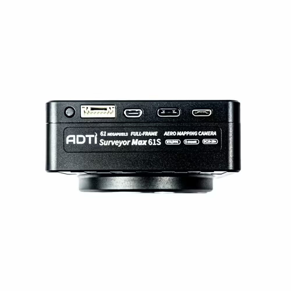
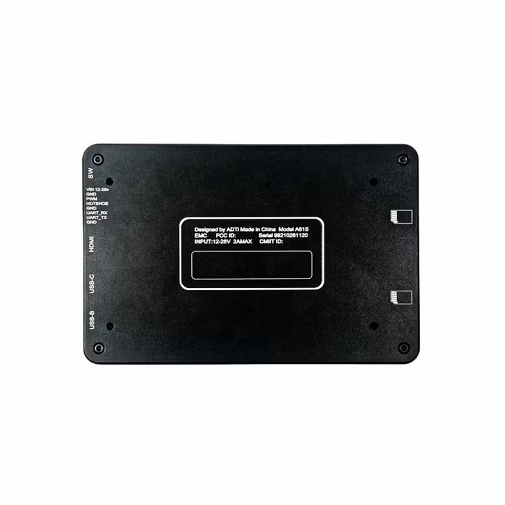
- Multi-Interface Hot Shoe Output for PPK Built-In: Seamlessly integrates with Post Processed Kinematic (PPK) systems for accurate geospatial data collection.
- High-Speed Continuous Shooting: With 10 frames per second, capture fast-moving subjects effortlessly. This Aerial Mapping Camera ensures critical moments are never missed.
- 4K Video Recording Capabilities: Ideal for both still photography and motion video in mapping projects, it records in stunning 4K resolution.
- Lightweight Construction: At just 276g, the camera’s lightweight design makes it simple to incorporate into various drone platforms without significant weight impact.
ADTi 61MP 61S Surveyor Drone Mapping Cameras: Superior Imaging Technology
The ADTi 61MP 61S Surveyor Drone Mapping Cameras boast cutting-edge imaging technology. Featuring a full-frame Sony CMOS sensor coupled with the Bionz X image processor, this ADTi Surveyor Camera delivers outstanding image quality, expansive dynamic range, and reduced noise, ideal for detailed and precise aerial photography.
ADTi 61MP 61S Surveyor Drone Mapping Cameras: Detailed Specifications
Image Sensor:
- Sensor Type: CMOS
- Sensor Manufacturer: Sony
- Effective Megapixels: 61
- Sensor Format: Full Frame
- Sensor Size: 849.6 mm² (35.7 x 23.8 mm)
- Pixel Pitch: 3.76 microns
- Aspect Ratio: 3:2
- Color Filter Type: RGBG
- Color Depth: 26 bits
- Maximum Effective ISO: 3,344
Image Capture:
- Image Resolution:
-
- 9504 x 6336 (60.2 MP, 3:2)
- 6240 x 4160 (26.0 MP, 3:2)
- 4752 x 3168 (15.1 MP, 3:2)
- 8448 x 6336 (53.5 MP, 4:3)
- 5552 x 4160 (23.1 MP, 4:3)
- 4224 x 3168 (13.4 MP, 4:3)
- 9504 x 5344 (50.8 MP, 16:9)
- 6240 x 3512 (21.9 MP, 16:9)
- 4752 x 2672 (12.7 MP, 16:9)
- 6336 x 6336 (40.1 MP, 1:1)
- 4160 x 4160 (17.3 MP, 1:1)
- 3168 x 3168 (10.0 MP, 1:1)
- Image File Format: JPEG, RAW (14-bit ARW 2.3), RAW+JPEG
- Continuous-mode frames/second: 10.0
Video Capture:
- Video Resolution:
-
- 3840×2160 (30p/25p/24p)
- 1920×1080 (120p/100p/60p/60i/50p/50i/30p/25p/24p)
- XAVC S / AVCHD 2.0 / MP4 is the video file format; LPCM / Dolby Digital (AC-3) / MPEG-4 AAC-LC, stereo
- HD Video Out: Yes
- HD Video Connection: HDMI
Lens & Optics:
- Lens Mount: Sony E
- Auto Focus: Yes
- Manual Focus: Yes
- Shutter Type: Mechanical shutter
- Shutter Speed: 1/8000-30 sec
Camera:
- Camera Size: 12 x 8 x 4.2 cm
- Camera Weight (body): 276 g
- Package Size: 50 x 50 x 25 cm
- Package Weight: 800 g
- Power: 12-28V DC Lipo or Li-ion
- Operating Temperature: -10 to 40°C
ADTi 61MP 61S Surveyor Drone Mapping Cameras: Versatile Compatibility
The ADTi 61MP 61S is compatible with the Airpixel R3, as well as the Gremsy Pixy U 3-axis camera gimbal and the ADTI 2-Axis nadir fixed-wing gimbal. The versatility of this High-Resolution Mapping Camera allows you to tailor your setup to the specific requirements of your surveying and mapping projects.
Elevate your aerial survey capabilities with the ADTi 61MP 61S Surveyor Drone Mapping Cameras. The advanced features, robust design, and superior imaging technology of this 61MP Surveyor Drone Camera ensure unmatched accuracy and efficiency in your mapping endeavors. Secure yours today and elevate your professional surveying to new heights.
ADTi 61MP 61S Surveyor Drone Mapping Cameras: Unmatched Image Quality
The ADTi 61MP 61S Surveyor Drone Mapping Cameras establish a new benchmark in aerial photography with their unmatched image quality. The 61MP full-frame Sony CMOS sensor captures every nuance with extraordinary clarity and accuracy, rendering this Professional Mapping Drone Camera perfect for intricate mapping and surveying projects. Equipped with the potent Bionz X image processor, it delivers superior dynamic range and minimal noise, even under difficult lighting scenarios.
ADTi 61MP 61S Surveyor Drone Mapping Cameras: Versatile Lens Compatibility
The ADTi 61MP 61S Surveyor Drone Mapping Cameras boast remarkable flexibility. They are compatible with an extensive array of E-mount full-frame lenses, encompassing ADTi’s own lightweight FF series, including the 18MM FF, 50MM FF, and 56MM FF lenses. This adaptability ensures that you can select the optimal lens for your particular mapping requirements, be it capturing expansive landscapes or detailed close-up shots.
ADTi 61MP 61S Surveyor Drone Mapping Cameras: Superior Video Capabilities
The ADTi 61MP 61S Surveyor Drone Mapping Cameras not only deliver remarkable still image quality but also excel in video recording. With support for 4K video capture, this ADTi 61MP Drone Camera guarantees that your aerial footage will be recorded with exceptional detail and clarity. Ideal for survey site documentation or producing videos of professional caliber, this camera provides superior video quality that adheres to the most stringent standards.
ADTi 61MP 61S Surveyor Drone Mapping Cameras: Lightweight And Durable Design
At just 276g, the ADTi 61MP 61S Surveyor Drone Mapping Cameras are crafted for seamless integration into diverse drone platforms, adding minimal weight. The durable ABS plastic housing guarantees longevity, rendering the Advanced Surveyor Drone Camera ideal for a variety of environmental conditions. Its compact design, paired with superior performance, renders it an excellent option for professional surveyors and mappers in need of dependable and portable equipment.
ADTi 61MP 61S Surveyor Drone Mapping Cameras: Seamless Integration With Surveying Equipment
The ADTi 61MP 61S Surveyor Drone Mapping Cameras are crafted for seamless integration with sophisticated surveying tools. This surveying drone camera is compatible with the Airpixel R3 and can be utilized with either the Gremsy Pixy S 3-axis camera gimbal or the ADTI 2-Axis nadir fixed-wing gimbal. Such compatibility allows for customization of your setup to meet the unique demands of your project, thereby improving the efficiency and precision of your aerial surveying tasks.
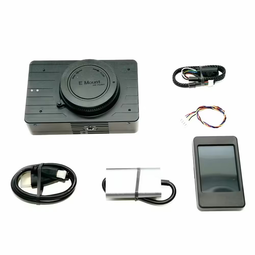
Package Include .
1 X ADTi 61MP 61S Surveyor Drone Mapping Cameras.
Related Products
- M2*6.5MM Rubber Shock Absorber Ball (Pack of 4)
- SIYI A8 mini Ultra HD 6X Digital Zoom Gimbal Camera
- (Discontinue )Skydroid Two Axis Gimbal Camera for T10/H12/T12 Radio Controller
ADTi 61MP 61S Surveyor Drone Mapping Cameras Overview
The ADTi 61MP 61S Surveyor Drone Mapping Cameras is a high-resolution aerial imaging solution designed for professional mapping and surveying applications. Equipped with a full-frame 61-megapixel Sony CMOS sensor, it delivers exceptional detail and accuracy for cartographers, surveyors, and GIS specialists.
Key Features of ADTi 61MP 61S Surveyor Drone Mapping Cameras
- 61 Megapixel full-frame Sony CMOS sensor captures ultra-high-resolution images
- Sensor size of 35.7 × 23.8 mm (849.6 mm²) ensures wide dynamic range and low noise
- 3.76 µm pixel pitch for precise terrain modeling and orthomosaic stitching
- E-mount compatibility supports ADTi FF lenses (18 mm, 50 mm, 56 mm) and other full-frame optics
- Durable construction built for demanding aerial survey environments
- Genuine product with fast shipping from Zbotic—orders ship within 24 hours
Applications and Use Cases
- Topographic mapping and digital elevation model (DEM) creation
- Precision agriculture for crop health assessment and yield estimation
- Construction site monitoring and volumetric measurement
- Forestry management and biomass analysis
- Infrastructure inspection of roads, pipelines, and power lines
- 3D photogrammetry for urban planning and heritage preservation
How to Use ADTi 61MP 61S Surveyor Drone Mapping Cameras
Mount the ADTi 61S camera onto your drone’s E-mount gimbal, attach a compatible full-frame lens, and secure all connectors. Configure exposure settings and focus in your ground control software, then plan your flight grid to ensure proper overlap. After the mission, download RAW or JPEG images for processing in photogrammetry or GIS software.
Why Buy from Zbotic?
- Genuine Products: All items sourced from authorized distributors
- Fast Shipping: Orders ship within 24 hours with tracking (non backordered products)
- Free Shipping: Free delivery on qualifying orders
- COD Available: Cash on Delivery, UPI, cards, net banking
- Technical Support: Expert help for setup and troubleshooting
- Easy Returns: Hassle-free replacement for defective products
Frequently Asked Questions
Which lenses are compatible with the ADTi 61S camera?
The ADTi 61S supports Sony E-mount full-frame lenses, including the ADTi FF series (18 mm, 50 mm, 56 mm). You can also use third-party E-mount full-frame optics that meet your focal length and weight requirements.
What image resolution and file format does this camera produce?
This camera produces 61 MP images at approximately 9280×6570 pixels. You can capture in RAW (Sony ARW) or high-quality JPEG, enabling detailed post-processing for orthomosaic and 3D model generation.
Can I integrate the camera with my existing drone system?
Yes, the ADTi 61S is designed for drones equipped with an E-mount gimbal interface. Ensure your gimbal supports the camera’s dimensions and weight, and configure power/data connections according to your flight controller’s documentation.

iNAV Setup Guide: GPS Autonomous Flight Step-by-Step
iNAV Setup Guide: GPS Autonomous Flight Step-by-Step iNAV (Inertial Navigation) is the premier open-source flight controller firmware for...
Read More →
FPV Goggles Buying Guide India: Analog vs Digital
Table of Contents Understanding FPV Goggles Buying Guide India Key Components and Requirements Step-by-Step Setup Guide Configuration and...
Read More →
ExpressLRS (ELRS) Setup Guide: From Flashing to First Bind
ExpressLRS (ELRS) Setup Guide: From Flashing to First Bind ExpressLRS has taken the FPV drone community by storm...
Read More →Technical Specifications
| Brand | ADTi |
|---|---|
| SKU | AI6060 |
| Availability | In Stock |
Applications & Use Cases
The ADTi 61MP 61S Surveyor Drone Mapping Cameras is a versatile drone gimbal and accessories used across a wide range of applications including electronics projects, DIY builds, prototyping, and educational experiments.
Common use cases:
- Integrating into a custom electronics project
- Learning and experimenting with circuits
- Replacing or upgrading components in existing setups
This product is ideal for electronics enthusiasts, engineers, and students.
Technical Tip: Always verify voltage and current requirements before connecting to your circuit. Check datasheets for detailed specifications and pin configurations.
Shipping & Delivery
- Free shipping on orders above ₹999 across India
- Dispatched within 1-3 business days
- Expected delivery: 3-7 business days depending on location
- Secure packaging to ensure safe transit of electronic components
- Genuine ADTi product sourced from authorized channels


Ashwin Gill (verified owner) –
Okay ADTi 61MP 61S Surveyor Drone Mapping. Gets the job done for my basic drone project. Nothing exceptional.
Siddharth Bhat (verified owner) –
Great ADTi 61MP 61S Surveyor Drone Mapping for beginners and professionals alike. Highly recommended for drone enthusiasts.
Aryan Banerjee (verified owner) –
Top quality ADTi 61MP 61S Surveyor Drone Mapping. I’m a regular customer of Zbotic and they never disappoint.
Sarthak Jain (verified owner) –
Great ADTi 61MP 61S Surveyor Drone Mapping for beginners and professionals alike. Highly recommended for drone enthusiasts.
Darshan Shetty (verified owner) –
This ADTi 61MP 61S Surveyor Drone Mapping is value for money. Comparing with other brands, Zbotic offers the best deal.
Yashwant Patel –
My 5th order from Zbotic. This ADTi 61MP 61S Surveyor Drone Mapping is excellent as always. Totally reliable store.
Zubin Srivastava (verified owner) –
This ADTi 61MP 61S Surveyor Drone Mapping exceeded my expectations. Installed it yesterday and took a successful test flight today.
Pallavi Ghosh –
Amazing build quality! This ADTi 61MP 61S Surveyor Drone Mapping is sturdy and lightweight at the same time.
Bharat Bisht (verified owner) –
Nice ADTi 61MP 61S Surveyor Drone Mapping, does the job. Delivery took a couple of extra days but product is solid.
Ayush Kulkarni (verified owner) –
Excellent product for the price. My drone flies smoothly with this ADTi 61MP 61S Surveyor Drone Mapping. Highly recommended!
Aman Rajan (verified owner) –
Decent ADTi 61MP 61S Surveyor Drone Mapping for the price. Using it in my quadcopter, performs well overall.
Lakshya Chopra (verified owner) –
Pretty good ADTi 61MP 61S Surveyor Drone Mapping. Works as expected for my drone project. Would buy again.
Naman Trivedi (verified owner) –
Great ADTi 61MP 61S Surveyor Drone Mapping for beginners and professionals alike. Highly recommended for drone enthusiasts.
Aryan Das –
Decent ADTi 61MP 61S Surveyor Drone Mapping. Took some effort to set up but working now.
Sandeep Verma (verified owner) –
Good quality ADTi 61MP 61S Surveyor Drone Mapping. Minor scratches on arrival but functionally perfect.
Pranav Srivastava (verified owner) –
Using this ADTi 61MP 61S Surveyor Drone Mapping in my FPV drone build. Quality is top notch. Very happy with the purchase.
Ankit Saini (verified owner) –
This ADTi 61MP 61S Surveyor Drone Mapping is value for money. Comparing with other brands, Zbotic offers the best deal.
Ankur Bhatt (verified owner) –
Using this ADTi 61MP 61S Surveyor Drone Mapping in my FPV drone build. Quality is top notch. Very happy with the purchase.