
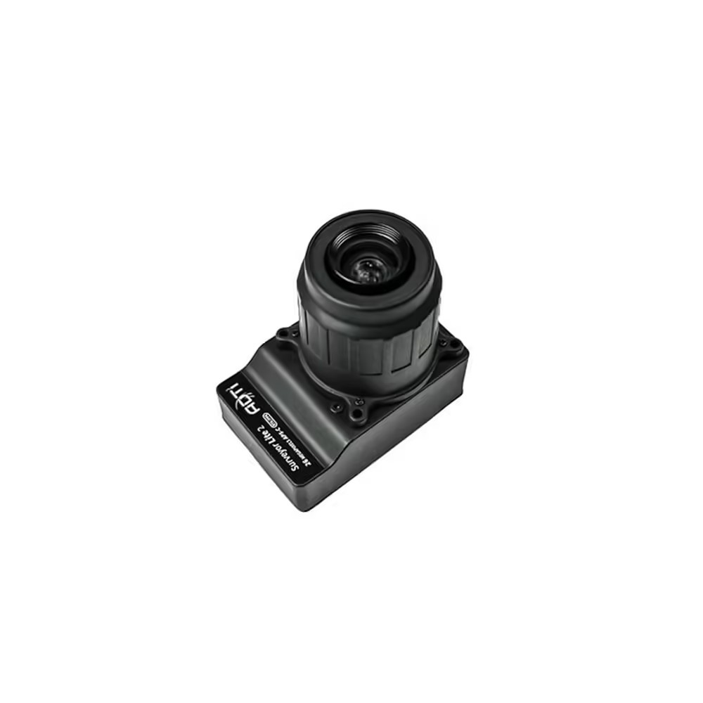


ADTi 26MP 26L V1 Surveyor Drone Mapping Cameras
Introducing the ADTi 26MP 26L V1 Surveyor Drone Mapping Cameras—the ultimate solution for professional aerial mapping and surveying. This state-of-the-art Surveyor Drone Camera is engineered to provide outstanding image quality and precision, making it an indispensable tool for surveyors and mapping professionals.
ADTi 26MP 26L V1 Surveyor Drone Mapping Cameras: Key Features
- APS-C Sony CMOS Sensor: The 26MP Drone Camera comes with a high-performance APS-C Sony CMOS sensor that captures high-resolution images with remarkable detail.
- Mechanical Shutter & Fixed Focus Lenses: Equipped with a mechanical shutter and fixed focus lenses, it delivers sharp, distortion-free images, ideal for intricate mapping tasks, making the ADTi Surveyor Drone Camera a top pick for drone enthusiasts.
- Built-in Multi-Interface Hot Shoe Output for PPK: The integrated multi-interface hot shoe output for PPK enables precise positioning and accurate geospatial data collection, thereby increasing the precision of mapping projects with this High-Resolution Drone Camera.
- Direct Geo-Tagging Function: The direct geo-tagging function allows for easy and immediate geo-tagging of images, simplifying the workflow and guaranteeing accurate data matching.
- ABS Plastic Housing: Its robust ABS plastic housing provides protection for the camera, ensuring the Aerial Survey Camera’s dependability under diverse environmental conditions.
ADTi 26MP 26L V1 Surveyor Drone Mapping Cameras: Technology For Superior Imaging
The ADTi 26MP 26L V1 Surveyor Drone Mapping Cameras are equipped with the Sony IMX571 sensor and the Socionext Imaging processor—Milbeaut®. These components work together to capture high-quality images while minimizing heat buildup, ensuring outstanding performance and durability, even with prolonged usage.
ADTi 26MP 26L V1 Surveyor Drone Mapping Cameras: Detailed Specifications
Image Sensor
- Sensor Type: CMOS
- Sensor Manufacturer: Sony
- Effective Megapixels: 26.1
- Sensor Format: APS-C
- Sensor Size: 365.04 mm² (23.4 mm x 15.6 mm)
- Pixel Pitch: 4.88 microns
- Aspect Ratio: 3:2
- Color Filter Type: RGBG
- Color Depth: 25.6 bits
- Maximum Effective ISO: 2,749
Image Capture:
- Image Resolution:
-
- 6192 x 4128 (26 MP, 3:2)
- 4800 x 3200 (15.4 MP, 3:2)
- 3680 x 2456 (9.0 MP, 3:2)
- 2400 x 1600 (3.8 MP, 3:2)
- Image File Format: JPEG
- Continuous-mode frames/second: 2.0
- Shutter Speed: MAX 0.7s, recommend 1s
Video Capture:
- Video Resolution:
-
- 1920×1080 (60p, 28Mbps)
- 640×480 (30p, 3Mbps)
- Video File Format: MP4
- HD Video Out: Yes
- HD Video Connection: HDMI
Lens & Optics:
- 25mm Fixed Lens:
-
- Manual fixed focus (ortho), NON-interchangeable
- 37.5mm Equivalent Focal Length
- FOV 59°
- Distortion < 0.5%
- Auto Focus: No
- Manual Focus: Yes
- Aperture: F5.6
Camera:
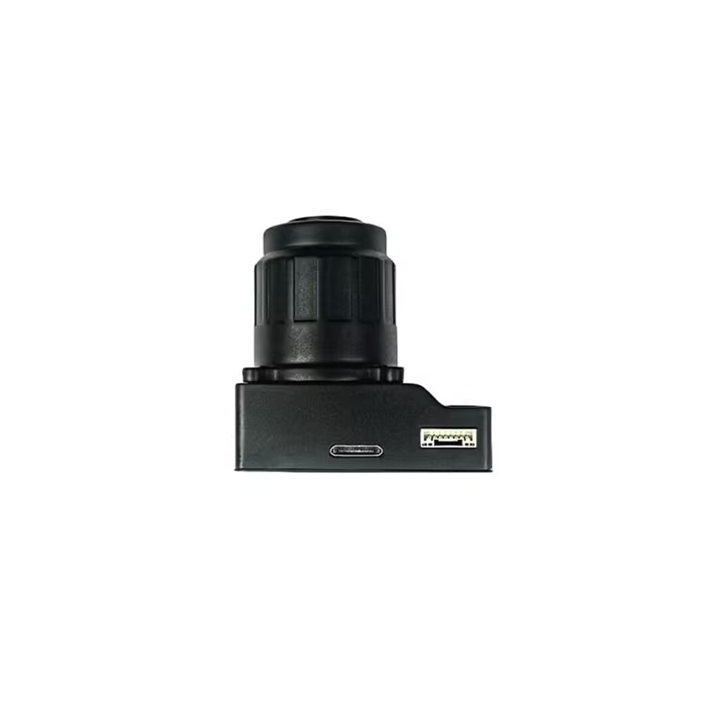
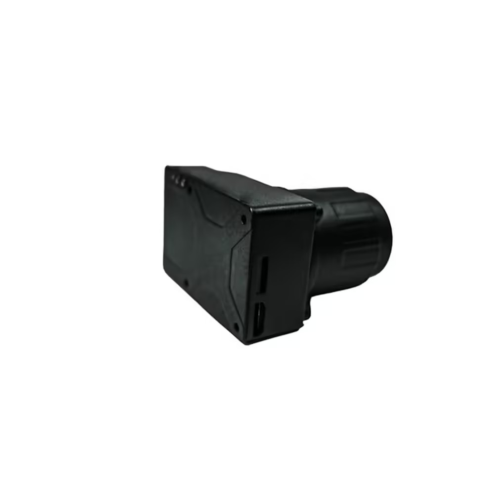
- Camera Size: 6.5 x 4.3 x 2.3 cm
- Weight with Lens: 71 g (camera module no housing) / 98 g (ABS plastic housing with 25mm lens)
- Package Size: 14.5 x 10 x 6 cm
- Package Weight: 500 g
- Power: 12-24V DC Lipo or Li-ion
- Operating Temperature: -10 to 40°C
Elevate your aerial survey capabilities with the ADTi 26MP 26L V1 Surveyor Drone Mapping Cameras. With its advanced features and sturdy design, this professional drone camera guarantees unmatched precision and efficiency for your mapping endeavors. Purchase this Drone Camera for Mapping now and step into the future of professional drone surveying.
ADTi 26MP 26L V1 Surveyor Drone Mapping Cameras offer unparalleled precision and clarity.
The ADTi 26MP 26L V1 Surveyor Drone Mapping Cameras deliver unparalleled precision and clarity. With a 26.1-megapixel APS-C Sony CMOS sensor, the 26MP Surveyor Drone Camera captures every detail with exceptional sharpness, ideal for high-resolution aerial mapping and surveying. Whether it’s mapping vast agricultural fields or conducting detailed urban surveys, the ADTi Drone Camera ensures comprehensive detail capture.
ADTi 26MP 26L V1 Surveyor Drone Mapping Cameras: Optimized for Professional Use
The ADTi 26MP 26L V1 Surveyor Drone Mapping Cameras are tailored for professional needs, offering features that meet the specific requirements of surveyors and mapping specialists. Its built-in multi-interface hot shoe output for PPK (Post Processed Kinematic) enables precise geolocation tagging, ensuring data accuracy and reliability. The direct geo-tagging feature also simplifies the workflow by reducing the time to match images with geospatial data.
ADTi 26MP 26L V1 Surveyor Drone Mapping Cameras: Robust and Reliable Design
The ADTi 26MP 26L V1 Surveyor Drone Mapping Cameras are designed for durability and reliability. Encased in ABS plastic housing for strong protection, the Surveyor Drone 26L V1 camera is built to endure the demands of fieldwork. Suitable for harsh environmental conditions or challenging terrains, the camera maintains consistent performance and longevity.
ADTi 26MP 26L V1 Surveyor Drone Mapping Cameras: Advanced Imaging Processor
The combination of the Socionext Imaging processor-Milbeaut® and the Sony IMX571 sensor ensures high-quality image capture with minimal heat generation. This sophisticated imaging technology not only improves image quality but also prolongs the operational life of the ADTi Surveyor Camera.
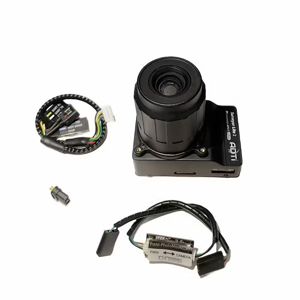
Package Include.
1 X ADTi 26MP 26L V1 Surveyor Drone Mapping Cameras.
ADTi 26MP 26L V1 Surveyor Drone Mapping Cameras Overview
The ADTi 26MP 26L V1 Surveyor Drone Mapping Camera is a professional-grade aerial imaging solution designed for precise photogrammetry and topographic surveys. Equipped with a high-performance Sony APS-C CMOS sensor and mechanical shutter, it delivers distortion-free, high-resolution images ideal for mapping applications.
Key Features of ADTi 26MP 26L V1 Surveyor Drone Mapping Cameras
- APS-C Sony CMOS Sensor: 26.1 effective megapixels on a 23.4 × 15.6 mm sensor for detailed aerial capture.
- Mechanical Shutter: Eliminates rolling shutter artifacts, ensuring accurate image geometry during high-speed flights.
- Fixed Focus Lenses: Factory-calibrated optics optimized for mapping distances, delivering consistent sharpness across the frame.
- High Pixel Resolution: 4.88 µm pixel pitch and 3:2 aspect ratio for precise ground sampling and data accuracy.
- Compact Form Factor: Lightweight, rugged housing designed for easy integration with survey-grade drone gimbals.
- Fast Shipping from Zbotic: Dispatch within 24 hours for in-stock items, ensuring minimal project delays.
Applications and Use Cases
- Topographic mapping of construction and mining sites
- Precision agriculture monitoring and crop health assessment
- Environmental surveys, forestry management, and habitat mapping
- Land parcel boundary documentation and cadastral surveys
- Archaeological site documentation and heritage preservation
- Infrastructure inspection and corridor mapping for utilities
How to Use ADTi 26MP 26L V1 Surveyor Drone Mapping Cameras
Mount the ADTi camera onto a compatible drone gimbal, secure the power and trigger connections, then perform a ground calibration to align the sensor. Configure flight parameters to cover your survey grid, set the capture interval or trigger input, and execute the mission. After flight, download the RAW or JPEG image files to your photogrammetry software for processing and map generation.
Why Buy from Zbotic?
- Genuine Products: All items sourced from authorized distributors
- Fast Shipping: Orders ship within 24 hours with tracking (non backordered products)
- Free Shipping: Free delivery on qualifying orders
- COD Available: Cash on Delivery, UPI, cards, net banking
- Technical Support: Expert help for setup and troubleshooting
- Easy Returns: Hassle-free replacement for defective products
Frequently Asked Questions
What is the field of view provided by this camera?
The APS-C sensor (23.4 × 15.6 mm) combined with the fixed-focus lens yields a wide field of view optimized for low-altitude survey flights, balancing coverage and ground sampling distance.
How does the mechanical shutter benefit mapping accuracy?
The mechanical shutter captures images instantaneously, removing rolling shutter distortions common in electronic shutters, which ensures each frame retains correct geometry for precise photogrammetric stitching.
Can I adjust the focus for different altitudes?
This model uses fixed focus lenses pre-set for typical mapping altitudes. The focus is calibrated at the factory to maintain sharpness from low to medium flight elevations without user adjustment.

T-Motor vs Emax vs BrotherHobby: Drone Motor Comparison India
Choosing between T-Motor, Emax, and BrotherHobby for your drone build in India comes down to budget, performance priorities,...
Read More →
FPV Drone LiPo Battery Maintenance: Storage and Longevity Guide
FPV Drone LiPo Battery Maintenance: Storage and Longevity Guide Your LiPo batteries are quite possibly the most expensive...
Read More →
Custom Flight Controller Build with STM32
Building a custom flight controller with STM32 is the ultimate drone electronics project. You design the PCB, select...
Read More →Technical Specifications
| Brand | ADTi |
|---|---|
| SKU | AI6067 |
| Availability | In Stock |
Applications & Use Cases
The ADTi 26MP 26L V1 Surveyor Drone Mapping Cameras is a versatile drone gimbal and accessories used across a wide range of applications including electronics projects, DIY builds, prototyping, and educational experiments.
Common use cases:
- Integrating into a custom electronics project
- Learning and experimenting with circuits
- Replacing or upgrading components in existing setups
This product is ideal for electronics enthusiasts, engineers, and students.
Technical Tip: Always verify voltage and current requirements before connecting to your circuit. Check datasheets for detailed specifications and pin configurations.
Shipping & Delivery
- Free shipping on orders above ₹999 across India
- Dispatched within 1-3 business days
- Expected delivery: 3-7 business days depending on location
- Secure packaging to ensure safe transit of electronic components
- Genuine ADTi product sourced from authorized channels


Kabir Luthra (verified owner) –
Received the ADTi 26MP 26L V1 Surveyor Drone in great condition. Testing done, everything works perfectly.
Sarika Dave (verified owner) –
Good product overall. My drone is flying well with this ADTi 26MP 26L V1 Surveyor Drone. Satisfied with the purchase.
Sarika Kulkarni (verified owner) –
Great ADTi 26MP 26L V1 Surveyor Drone for beginners and professionals alike. Highly recommended for drone enthusiasts.
Kritika Panchal (verified owner) –
Bought this for my college drone project. Works great, professor was impressed!
Varun Banerjee (verified owner) –
Bought this for my college drone project. Works great, professor was impressed!
Darshan Bhandari (verified owner) –
My 5th order from Zbotic. This ADTi 26MP 26L V1 Surveyor Drone is excellent as always. Totally reliable store.
Rishabh Thakur (verified owner) –
Top quality ADTi 26MP 26L V1 Surveyor Drone. I’m a regular customer of Zbotic and they never disappoint.
Advik Desai (verified owner) –
Pretty good ADTi 26MP 26L V1 Surveyor Drone. Works as expected for my drone project. Would buy again.
Dev Pandey (verified owner) –
Good product overall. My drone is flying well with this ADTi 26MP 26L V1 Surveyor Drone. Satisfied with the purchase.
Deepak Gill (verified owner) –
Very impressed with this ADTi 26MP 26L V1 Surveyor Drone. My drone’s performance improved noticeably.
Harsh Deshpande (verified owner) –
Good product overall. My drone is flying well with this ADTi 26MP 26L V1 Surveyor Drone. Satisfied with the purchase.
Neeraj Reddy –
Been using this ADTi 26MP 26L V1 Surveyor Drone for 3 months now, zero issues. Great product.
Prashant Batra (verified owner) –
This ADTi 26MP 26L V1 Surveyor Drone is value for money. Comparing with other brands, Zbotic offers the best deal.
Vidya Panchal (verified owner) –
Excellent ADTi 26MP 26L V1 Surveyor Drone! Perfect for my quadcopter build. Arrived well packed and works flawlessly.
Lokesh Deshpande (verified owner) –
Decent ADTi 26MP 26L V1 Surveyor Drone. Took some effort to set up but working now.
Om Reddy (verified owner) –
Bought this for my college drone project. Works great, professor was impressed!
Krishna Parekh (verified owner) –
Using this ADTi 26MP 26L V1 Surveyor Drone in my hexacopter. Smooth operation and excellent thrust.
Uday Nayak (verified owner) –
Superb ADTi 26MP 26L V1 Surveyor Drone! Built my first drone with this and it performed beyond expectations.
Sandeep Nair (verified owner) –
Very impressed with this ADTi 26MP 26L V1 Surveyor Drone. My drone’s performance improved noticeably.
Vishal Khurana (verified owner) –
Perfect for my agriculture drone project. This ADTi 26MP 26L V1 Surveyor Drone handles the weight effortlessly.
Dev Goyal –
Very good quality ADTi 26MP 26L V1 Surveyor Drone. I’ve been building drones for 2 years now and this is one of the best I’ve used.