


(DISCONTINUE) ADTi Camera: 26MP 26S V2 Surveyor Drone Mapping Camera
Enhance your surveying and mapping endeavors with the ADTi Camera 26MP 26S V2 Surveyor Drone Mapping Camera module. The ADTi 26MP 26S V2 Surveyor Drone Camera represents the pinnacle of imaging solutions, tailored for professionals seeking precision and dependability. This sophisticated ADTi Mapping Camera, crafted by ADTI, incorporates the latest technology to provide unmatched performance in aerial photography and mapping.
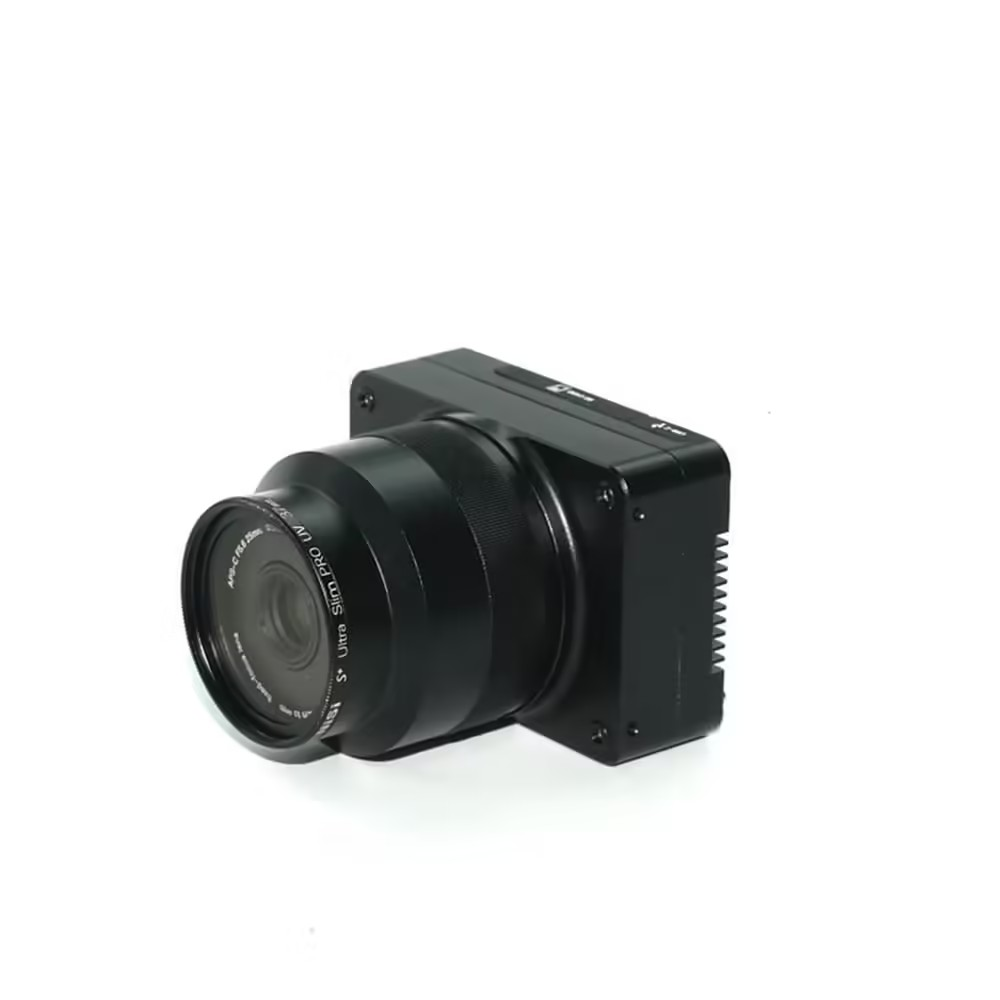
The (DISCONTINUE) ADTi Camera 26MP 26S V2 Surveyor Drone Mapping Camera is designed to meet the demands of precision and adaptability in a variety of surveying contexts. Equipped with a Sony IMX 571 back-illuminated 26MP APS-C sensor, this ADTi Mapping Camera boasts high-resolution imaging capabilities. This sensor ensures exceptional image quality with remarkable detail, even under challenging lighting conditions. The synergy between the Sony IMX 571 sensor and the Socionext Imaging processor-Milbeaut® results in crisp, sharp images with minimal heat generation, making the ADTi 26MP 26S V2 Mapping Camera for drones perfectly suited for intricate aerial surveys.
ADTi Camera: Versatile Lens Options As Well As Mechanical Shutter
The (DISCONTINUE) ADTi Camera 26MP 26S V2 Surveyor Drone Mapping Camera boasts a versatile lens system as one of its key features. This ADTi Mapping Camera comes with a selection of fixed lenses, including options of 16mm, 25mm, and 35mm. Each lens is tailored for certain focal lengths, providing accurate imaging for a variety of surveying and mapping tasks. The 16mm lens offers a broad field of view, ideal for extensive area surveys, while the 35mm lens captures detailed, sharp images for projects that require a closer look. The mechanical global shutter ensures consistent and reliable image capture, making the ADTi 26MP 26S V2 Surveyor Camera a top choice for professional use.
ADTi Camera: Advanced Geo-Tagging And Real-Time Streaming
Professionals in need of precise geospatial data will find the ADTi 26MP 26S V2 to be a valuable tool, especially with its direct geo-tagging feature when used alongside the ADTI POS & CTRL unit (available separately). This capability ensures accurate synchronization of images with geographic coordinates. The ADTi 26MP 26S V2 Drone Mapping Camera is crucial for generating precise maps and models. Moreover, the camera’s Ethernet port facilitates live video streaming, which permits on-the-fly monitoring of aerial surveys, thereby improving operational efficiency and enabling instant in-flight adjustments.
ADTi Camera: Durable And Lightweight Construction
The 26MP 26S V2 Surveyor Drone Mapping Camera boasts a robust full aluminum frame as part of its design. The ADTi 26MP 26S V2 Survey and Mapping Camera combines durability with a lightweight profile, weighing only 110 grams with the lens. These 26MP 26S V2 ADTi Drone Mapping Cameras can be easily integrated into various drone platforms without sacrificing performance. The ADTi Surveyor Drone Camera 26MP 26S V2’s compact size and sturdy construction make it ideal for challenging environments and prolonged field use.
ADTi Camera: Technical Specifications
- Sensor Type: CMOS
- Sensor Manufacturer: Sony
- Sensor Model: Sony IMX 571 back-illuminated
- Effective Megapixels: 26.1 MP
- Sensor Format: APS-C
- Sensor Size: 368.95mm² (23.5 x 15.7mm), Diagonal 28.3mm
- Pixel Size: 3.76 μm (H) x 3.76 μm (V)
- Aspect Ratio: 3:2
- Color Depth: 25.6 bits
- Maximum ISO: 2,749
Image Capture:
- Resolution Options:
-
- 6252 x 4168 (26 MP)
- 4800 x 3200 (15.4 MP)
- 3680 x 2456 (9.0 MP)
- 2400 x 1600 (3.8 MP)
- File Format: JPEG
- Shutter Type: Lightweight inter-mirror mechanical, replaceable
- Shutter Speed: 1/100 to 1/10000
- Continuous Mode Frames/Second: 2.0
- Expo Interval: ≥0.5s
Video Capture:
- Resolution:
-
- 1920×1080 (60p, 28Mbps)
- 640×480 (30p, 3Mbps)
- File Format: MP4
- HD Video Output: Yes
- HD Video Connection: HDMI
Lens & Optics:
- 16mm Fixed Lens:
-
-
- Equivalent Focal Length: 24.5mm
- FOV: D 83.0°, H 73.0°, V 52.0°
- Distortion: <0.01%
- Aperture: Fixed F5.6
-
- 25mm Fixed Lens:
-
-
- Equivalent Focal Length: 37.5mm
- FOV: D 58.7°, H 50.0°, V 34.4°
- Distortion: <0.5%
- Aperture: Fixed F5.6
-
- 35mm Fixed Lens:
-
- Equivalent Focal Length: 52mm
- FOV: D 44.1°, H 37.2°, V 25.3°
- Distortion: <0.02%
- Aperture: Fixed F5.6
Camera Dimensions:
- Size: 6.88 x 4.85 x 6.25 cm
- Weight with Lens: 110 g
- Package Size: 14.5 x 10 x 6 cm
- Package Weight: 500 g
Power and Temperature:
- Power Supply: 12-28V DC LiPo or Li-ion
- Operating Temperature: -10 to 40 °C
ADTi Camera: Power And Operating Conditions
The 26MP 26S V2 ADTi Surveyor Drone Camera is powered by a 12-28V DC LiPo or Li-ion battery, offering wide-ranging compatibility with numerous drone systems. Engineered for mapping, the ADTi Drone Camera 26MP 26S V2 operates efficiently across a temperature spectrum of -10°C to 40°C, accommodating a variety of weather conditions.
ADTi Camera: Limited Stocks Available! Call Us Now
The ADTi Camera: 26MP 26S V2 Surveyor Drone Mapping Camera is a high-performance imaging solution that merges advanced technology with practical features to fulfill the rigorous demands of aerial surveying and mapping. It is suitable for detailed land surveys, infrastructure inspections, or extensive mapping projects. The ADTi Surveyor Mapping Camera 26MP 26S V2 offers precision, versatility, and reliability, enhancing your aerial imaging capabilities.
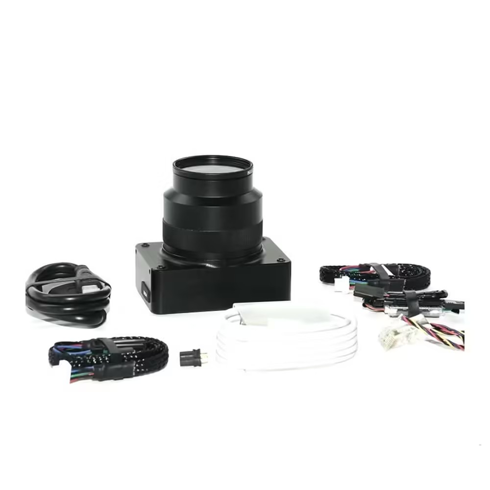
Package Include.
1 X ADTi 26MP 26S V2 Surveyor Drone Mapping Cameras.
(DISCONTINUE) ADTi 26MP 26S V2 Surveyor Drone Mapping Cameras Overview
The ADTi 26MP 26S V2 is a professional-grade mapping camera module designed for aerial surveying platforms. Equipped with a Sony IMX 571 back-illuminated APS-C sensor, it delivers 26.1 megapixel stills optimized for high-resolution orthomosaic and photogrammetric workflows.
Key Features of ADTi 26MP 26S V2 Surveyor Drone Mapping Cameras
- 26.1 MP Sony IMX 571 back-illuminated CMOS for superior light sensitivity
- APS-C sensor format (23.5 × 15.7 mm) providing detailed coverage per flight pass
- High dynamic range and low-noise capture ideal for varied lighting conditions
- Durable, precision-machined housing built for UAV payload integration
- Outputs raw image data for advanced photogrammetry processing
- Genuine product with fast shipping from Zbotic
Applications and Use Cases
- Topographic mapping and terrain modelling for civil engineering projects
- Agricultural crop health monitoring via high-resolution orthomosaics
- Construction site progress tracking and volumetric measurements
- Environmental and forestry surveys to assess land cover changes
- Urban planning and infrastructure inspection requiring precise geospatial data
- Archaeological site documentation with detailed aerial imagery
How to Use ADTi 26MP 26S V2 Surveyor Drone Mapping Cameras
Mount the ADTi 26S V2 module onto your UAV’s compatible gimbal or payload bay, connect to the drone’s power and data interfaces, then configure capture intervals in your flight planning software. Execute grid or waypoint missions to acquire overlapping stills, and download the RAW images post-flight for photogrammetric processing.
Why Buy from Zbotic?
- Genuine Products: All items sourced from authorized distributors
- Fast Shipping: Orders ship within 24 hours with tracking (non backordered products)
- Free Shipping: Free delivery on qualifying orders
- COD Available: Cash on Delivery, UPI, cards, net banking
- Technical Support: Expert help for setup and troubleshooting
- Easy Returns: Hassle-free replacement for defective products
Frequently Asked Questions
What makes the Sony IMX 571 sensor ideal for mapping?
The back-illuminated design and APS-C format deliver high dynamic range and low noise, providing crisp, detailed imagery for accurate orthomosaic and elevation model generation.
Can I integrate this camera with my existing survey drone?
The ADTi 26S V2 module is designed for standard UAV gimbal mounts and power interfaces used in professional surveying platforms. Verify your drone’s payload capacity and mounting dimensions to ensure compatibility.
How do I process the images captured by this camera?
Import the high-resolution RAW outputs into photogrammetry software such as Pix4D, Agisoft Metashape, or DroneDeploy to generate orthomosaics, DSMs, 3D meshes and contour maps.

Custom Flight Controller Build with STM32
Building a custom flight controller with STM32 is the ultimate drone electronics project. You design the PCB, select...
Read More →
FPV Camera & Video Transmitter Buying Guide
A good FPV camera and VTX (video transmitter) combo is what turns a flying quad into a truly...
Read More →
INAV vs Betaflight vs ArduPilot: Which Flight Firmware?
Table of Contents Overview: The Three Firmware Giants Betaflight – The FPV Racer's Choice INAV – Navigation Made...
Read More →Technical Specifications
| Brand | ADTi |
|---|---|
| SKU | AI6065 |
| Availability | Out of Stock |
Applications & Use Cases
The (DISCONTINUE) ADTi 26MP 26S V2 Surveyor Drone Mapping Cameras is a versatile drone gimbal and accessories used across a wide range of applications including electronics projects, DIY builds, prototyping, and educational experiments.
Common use cases:
- Integrating into a custom electronics project
- Learning and experimenting with circuits
- Replacing or upgrading components in existing setups
This product is ideal for electronics enthusiasts, engineers, and students.
Technical Tip: Always verify voltage and current requirements before connecting to your circuit. Check datasheets for detailed specifications and pin configurations.
Shipping & Delivery
- Free shipping on orders above ₹999 across India
- Dispatched within 1-3 business days
- Expected delivery: 3-7 business days depending on location
- Secure packaging to ensure safe transit of electronic components
- Genuine ADTi product sourced from authorized channels


Rashmi Malhotra (verified owner) –
Using this ADTi 26MP 26S V2 Surveyor Drone in my FPV drone build. Quality is top notch. Very happy with the purchase.
Vansh Goyal (verified owner) –
Good ADTi 26MP 26S V2 Surveyor Drone. Works well for my drone build. Packaging could be slightly better.
Kabir Krishnan (verified owner) –
Decent ADTi 26MP 26S V2 Surveyor Drone for the price. Using it in my quadcopter, performs well overall.
Sumit Negi (verified owner) –
Superb ADTi 26MP 26S V2 Surveyor Drone! Built my first drone with this and it performed beyond expectations.
Krishna Trivedi (verified owner) –
Very impressed with this ADTi 26MP 26S V2 Surveyor Drone. My drone’s performance improved noticeably.
Pooja Mehta –
Excellent product for the price. My drone flies smoothly with this ADTi 26MP 26S V2 Surveyor Drone. Highly recommended!
Chirag Joshi –
Superb ADTi 26MP 26S V2 Surveyor Drone! Built my first drone with this and it performed beyond expectations.
Priya Nair (verified owner) –
Great quality ADTi 26MP 26S V2 Surveyor Drone. Perfect specs for my drone project. Fast delivery too!
Rishabh Dave (verified owner) –
Nice ADTi 26MP 26S V2 Surveyor Drone, does the job. Delivery took a couple of extra days but product is solid.
Ayush Banerjee (verified owner) –
Nice ADTi 26MP 26S V2 Surveyor Drone, does the job. Delivery took a couple of extra days but product is solid.
Arnav Kulkarni –
Bought this for my college drone project. Works great, professor was impressed!
Neha Vohra (verified owner) –
Received the ADTi 26MP 26S V2 Surveyor Drone in great condition. Testing done, everything works perfectly.
Anirudh Banerjee (verified owner) –
Very impressed with this ADTi 26MP 26S V2 Surveyor Drone. My drone’s performance improved noticeably.
Vikram Das (verified owner) –
Decent ADTi 26MP 26S V2 Surveyor Drone for the price. Using it in my quadcopter, performs well overall.