
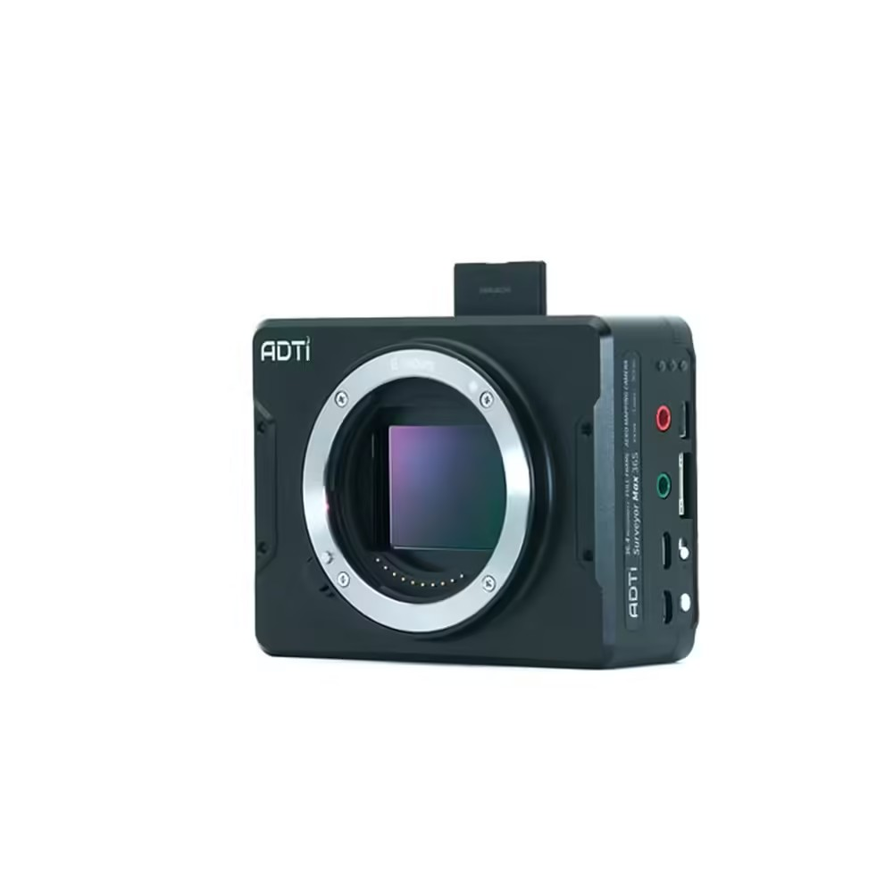


ADTi 36MP 36S Surveyor Drone Mapping Cameras For You
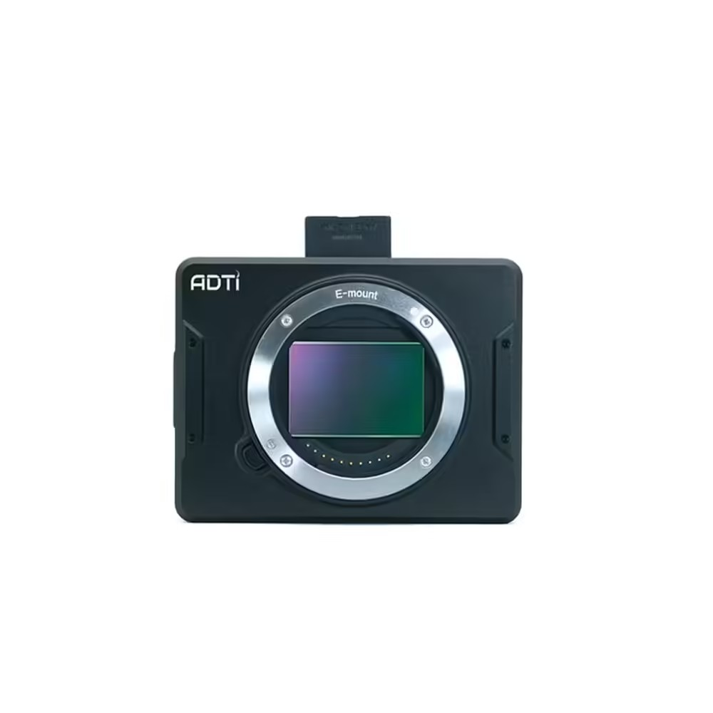
Enhance your aerial surveying and mapping endeavors with the ADTi 36MP 36S Surveyor Drone Mapping Cameras. Crafted for accuracy and adaptability, this high-grade drone lens camera boasts a 36.3-megapixel full-frame CMOS sensor, along with sophisticated features, to provide exceptional imaging results.
ADTi 36MP 36S Surveyor Drone Mapping Cameras: Key Features
- 36.3 Megapixel Full-Frame CMOS Sensor: The high-resolution sensor captures stunningly detailed images, making the ADTi 36MP 36S Mapping Camera ideal for intricate surveys and maps.
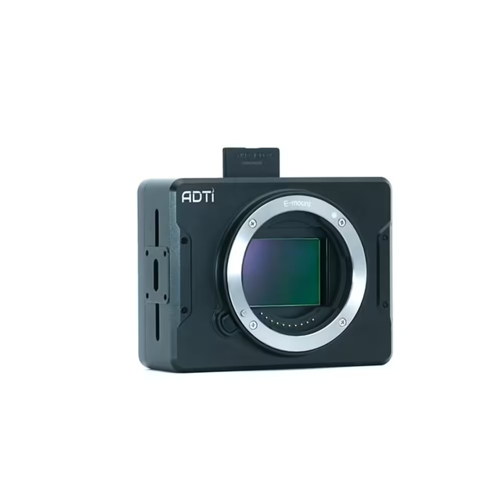
- E-Mount with Lens Support: Compatible with FE, E, and A-mount lenses (via adapter), the ADTi 36MP Surveyor Camera offers versatile lens options to suit a variety of shooting requirements.
- Bionz X Image Processor: The ADTi 36S Drone Camera boasts rapid image processing and exceptional quality with its Bionz X Image Processor.
- Multi-Interface Hot Shoe Output for PPK: Enhancing geotagging precision and efficiency, the ADTi Surveyor Drone Camera 36MP features a multi-interface hot shoe output for PPK.
- Exceptional Dynamic Range and Low Noise: The 36MP ADTi 36S Mapping Camera ensures clear, high-quality images in various lighting conditions with its superior dynamic range and low noise capabilities.
- Industrial Full Aluminum Design: With its durable and robust full aluminum design, the ADTi Drone Surveyor Camera 36S is built to endure challenging environments.
- Lightweight Design: At just 240g, the ADTi 36MP 36S Aerial Mapping Camera is ideally suited for integration into diverse drone platforms.
ADTi 36MP 36S Surveyor Drone Mapping Cameras: Detailed Specifications
Image Sensor:
- Sensor Type: CMOS
- Sensor Manufacturer: Sony
- Effective Megapixels: 36.4
- Sensor Format: Full Frame
- Sensor Size: 861.6mm² (35.9mm x 24mm)
- Approximate Pixel Pitch: 4.88 microns
- Focal Length Multiplier: 1.0x
- Aspect Ratio: 3:2
- Color Filter Type: RGBG
- Anti-Aliasing Filter: None
- Color Depth (bits): 25.6
- Maximum Effective ISO: 2,749
Image Capture:
- Image Resolution:
-
- 7360 x 4912 (36.2 MP, 3:2)
- 4800 x 3200 (15.4 MP, 3:2)
- 3680 x 2456 (9.0 MP, 3:2)
- 7360 x 4144 (30.5 MP, 16:9)
- 4800 x 2704 (13.0 MP, 16:9)
- 3680 x 2072 (7.6 MP, 16:9)
- 12416 x 1856 (23.0 MP, Other)
- 8192 x 1856 (15.2 MP, Other)
- 2160 x 5536 (12.0 MP, Other)
- 2160 x 3872 (8.4 MP, Other)
- Image File Format: JPEG, RAW (14-bit ARW 2.3), RAW+JPEG
- Continuous-mode frames/second: 3.0
Video Capture:
- Video Resolution:
-
- 1920×1080 (60p/60i/24p)
- 1440×1080 (30p)
- 640×480 (30p)
- Video File Format: AVCHD 2.0 / MP4
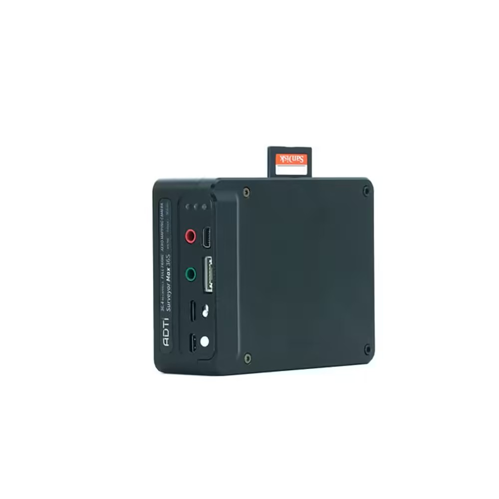
- HD Video Out: Yes
- HD Video Connection: HDMI
Lens & Optics:
- Lens Mount: Sony E
- Auto Focus: Yes
- Manual Focus: Yes
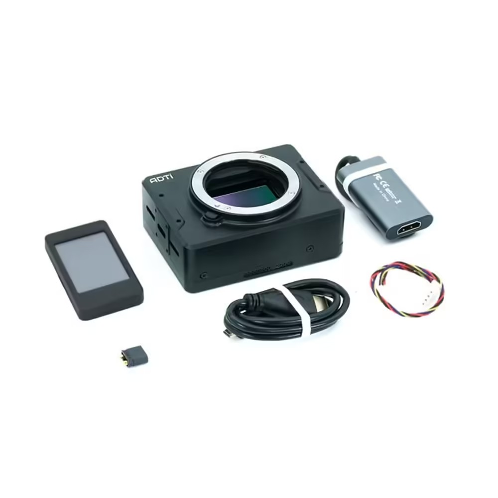
Display (detached):
- Power: 5V DC
- Buttons: Yes
- Screen Size: 5 inch
Camera:
- Camera Size: 9.4 x 7.2 x 3.3 cm
- Camera Weight: 240 g
- Package Size: 30 x 30 x 25 cm
- Package Weight: 700 g
- Power: 10-25V DC Lipo or Li-ion
- Operating Temperature: -10 to 40 °C
ADTi 36MP 36S Surveyor Drone Mapping Cameras: Advanced Imaging Performance
The ADTi 36MP 36S Surveyor Drone Mapping Cameras excel with their superior dynamic range and exceptionally low noise levels. The ADTi 36S 36MP Camera for Drone Mapping guarantees that each photograph captures the true essence of the landscape, whether in bright sunlight or low-light conditions. The ADTi 36MP 36S UAV Camera consistently delivers high-quality images, making it an indispensable tool for professional surveyors and mappers.
ADTi 36MP 36S Surveyor Drone Mapping Cameras: Versatility in Lens Selection
The ADTi 36MP 36S supports FE, E, and A-mount lenses (with an adapter), offering unmatched flexibility. This versatility allows users to select the ideal lens for every project, ensuring the 36S ADTi 36MP Surveyor Drone Camera achieves optimal results in any surveying environment. The E-mount system further enhances the camera’s adaptability, making it the preferred choice for a variety of aerial imaging requirements.
ADTi 36MP 36S Surveyor Drone Mapping Cameras: Robust and Lightweight Design
Crafted from industrial-grade aluminum, the ADTi 36MP 36S is both robust and lightweight, weighing just 240g. This UAV Mapping Camera reduces the impact on drone flight dynamics while providing the durability needed to withstand demanding field conditions. The combination of sturdiness and lightness ensures that the High-Resolution Surveyor Camera meets the challenges of extensive aerial surveys.
ADTi 36MP 36S Surveyor Drone Mapping Cameras: Comprehensive Image and Video Capabilities
The Drone Lens camera excels in still photography and video recording. Offering resolutions up to 1920×1080 at 60p, it captures detailed and fluid footage suitable for various applications, from topographical mapping to infrastructure inspection. The HDMI output facilitates seamless integration into diverse video workflows, ensuring comprehensive capture capabilities.
Package Include.
1 X ADTi 36MP 36S Surveyor Drone Mapping Cameras.
ADTi 36MP 36S Surveyor Drone Mapping Cameras Overview
The ADTi 36MP 36S Surveyor Drone Mapping Camera is a high-resolution imaging module designed for professional aerial surveying and mapping. With its full-frame Sony CMOS sensor and versatile E-mount compatibility, it delivers detailed, geospatially accurate photographs ideal for terrain analysis and 3D reconstruction.
Key Features of ADTi 36MP 36S Surveyor Drone Mapping Cameras
- 36.3 Megapixel Full-Frame Sony CMOS Sensor: Captures ultra-detailed imagery for precise survey outputs.
- E-Mount Lens Compatibility: Supports native FE/E lenses and A-mount optics via adapter for flexible focal lengths.
- High Dynamic Range: Retains detail in highlights and shadows, enhancing mapping accuracy.
- Optimized for Aerial Platforms: Compact, lightweight design integrates seamlessly with common drone gimbals.
- Raw and JPEG Output: Offers uncompressed RAW files for post-processing alongside quick-review JPEGs.
- Fast Shipping from Zbotic: Orders processed within 24 hours and dispatched with tracking information.
Applications and Use Cases
- Topographic surveying and contour mapping for civil engineering projects
- Agricultural crop health monitoring through high-resolution multispectral overlays
- Construction site progress documentation and stockpile volume calculations
- Archaeological site surveying and heritage preservation mapping
- Disaster management assessments, including floodplain and landslide analysis
- Urban planning and infrastructure inspection with precise georeferenced imagery
How to Use ADTi 36MP 36S Surveyor Drone Mapping Cameras
Mount the ADTi camera to your compatible drone gimbal using the provided E-mount interface or adapter, attach your preferred lens, and connect the camera’s control cable to your drone’s flight controller. Configure capture settings in your ground station software, plan your flight grid, and initiate automated image acquisition to generate high-resolution, geotagged photographs for downstream photogrammetry.
Why Buy from Zbotic?
- Genuine Products: All items sourced from authorized distributors
- Fast Shipping: Orders ship within 24 hours with tracking (non backordered products)
- Free Shipping: Free delivery on qualifying orders
- COD Available: Cash on Delivery, UPI, cards, net banking
- Technical Support: Expert help for setup and troubleshooting
- Easy Returns: Hassle-free replacement for defective products
Frequently Asked Questions
What lens mounts are supported by the ADTi 36MP 36S Surveyor Camera?
The camera uses a native Sony E-mount and, with an optional adapter, can accept A-mount lenses. This lets you choose from a wide range of FE, E, and adapted A-mount optics to suit your focal length needs.
How are images stored and accessed during flight?
Images are captured in both RAW and JPEG formats on a removable SD card. After the flight, simply remove the card and transfer files to your computer for photogrammetric processing.
Can this camera handle low-light or high-contrast surveying conditions?
Yes. The full-frame Sony CMOS sensor offers high dynamic range, preserving detail in shadows and highlights, making it ideal for dawn, dusk, or variable light scenarios encountered during aerial surveys.

Drone Thermal Imaging: Search and Rescue Applications
Table of Contents Understanding Drone Thermal Imaging Key Components and Requirements Step-by-Step Setup Guide Configuration and Optimisation Practical...
Read More →
INAV vs Betaflight vs ArduPilot: Which Flight Firmware?
Table of Contents Overview: The Three Firmware Giants Betaflight – The FPV Racer's Choice INAV – Navigation Made...
Read More →
FPV Freestyle vs Racing Drone: Which Build Is Right for You?
Table of ContentsIntroduction: Two Worlds Under One HobbyWhat Is FPV Freestyle?What Is FPV Racing?Frame DifferencesMotor and Prop ChoicesESC...
Read More →Technical Specifications
| Brand | ADTi |
|---|---|
| SKU | AI6064 |
| Availability | In Stock |
Applications & Use Cases
The ADTi 36MP 36S Surveyor Drone Mapping Cameras is a versatile drone gimbal and accessories used across a wide range of applications including electronics projects, DIY builds, prototyping, and educational experiments.
Common use cases:
- Integrating into a custom electronics project
- Learning and experimenting with circuits
- Replacing or upgrading components in existing setups
This product is ideal for electronics enthusiasts, engineers, and students.
Technical Tip: Always verify voltage and current requirements before connecting to your circuit. Check datasheets for detailed specifications and pin configurations.
Shipping & Delivery
- Free shipping on orders above ₹999 across India
- Dispatched within 1-3 business days
- Expected delivery: 3-7 business days depending on location
- Secure packaging to ensure safe transit of electronic components
- Genuine ADTi product sourced from authorized channels
Aditya Shah (verified owner) –
Amazing build quality! This ADTi 36MP 36S Surveyor Drone Mapping is sturdy and lightweight at the same time.
Rashmi Iyer –
This ADTi 36MP 36S Surveyor Drone Mapping is value for money. Comparing with other brands, Zbotic offers the best deal.
Bhavna Sharma (verified owner) –
Using this ADTi 36MP 36S Surveyor Drone Mapping in my hexacopter. Smooth operation and excellent thrust.
Priya Grewal (verified owner) –
Using this ADTi 36MP 36S Surveyor Drone Mapping in my FPV drone build. Quality is top notch. Very happy with the purchase.
Sneha Rathore (verified owner) –
Good ADTi 36MP 36S Surveyor Drone Mapping. Works well for my drone build. Packaging could be slightly better.
Nikita Kulkarni (verified owner) –
Average ADTi 36MP 36S Surveyor Drone Mapping. Works fine but expected slightly better quality at this price.
Yashwant Kulkarni (verified owner) –
Pretty good ADTi 36MP 36S Surveyor Drone Mapping. Works as expected for my drone project. Would buy again.
Hemant Menon (verified owner) –
This ADTi 36MP 36S Surveyor Drone Mapping exceeded my expectations. Installed it yesterday and took a successful test flight today.
Siddharth Joshi –
This ADTi 36MP 36S Surveyor Drone Mapping is exactly what I needed for my drone. Works perfectly, very reliable.
Atharv Vyas (verified owner) –
My 5th order from Zbotic. This ADTi 36MP 36S Surveyor Drone Mapping is excellent as always. Totally reliable store.
Chetan Choudhury –
Bought this for my college drone project. Works great, professor was impressed!
Swati Solanki (verified owner) –
Very impressed with this ADTi 36MP 36S Surveyor Drone Mapping. My drone’s performance improved noticeably.
Aditya Gupta (verified owner) –
Decent ADTi 36MP 36S Surveyor Drone Mapping for the price. Using it in my quadcopter, performs well overall.
Lokesh Singh (verified owner) –
Average ADTi 36MP 36S Surveyor Drone Mapping. Works fine but expected slightly better quality at this price.
Kapil Reddy –
Using this ADTi 36MP 36S Surveyor Drone Mapping in my hexacopter. Smooth operation and excellent thrust.
Ashwin Sen (verified owner) –
Decent ADTi 36MP 36S Surveyor Drone Mapping for the price. Using it in my quadcopter, performs well overall.
Tanmay Pillai (verified owner) –
This ADTi 36MP 36S Surveyor Drone Mapping is exactly what I needed for my drone. Works perfectly, very reliable.
Sumit Dubey –
Solid ADTi 36MP 36S Surveyor Drone Mapping. Not the absolute best but excellent value for the price point.
Vidya Arora (verified owner) –
Good quality ADTi 36MP 36S Surveyor Drone Mapping. Minor scratches on arrival but functionally perfect.
Ananya Negi (verified owner) –
Amazing build quality! This ADTi 36MP 36S Surveyor Drone Mapping is sturdy and lightweight at the same time.
Shubham Das (verified owner) –
Amazing build quality! This ADTi 36MP 36S Surveyor Drone Mapping is sturdy and lightweight at the same time.
Tanmay Chauhan –
Amazing build quality! This ADTi 36MP 36S Surveyor Drone Mapping is sturdy and lightweight at the same time.
Sunil Trivedi (verified owner) –
Nice ADTi 36MP 36S Surveyor Drone Mapping, does the job. Delivery took a couple of extra days but product is solid.
Chirag Malhotra (verified owner) –
Superb ADTi 36MP 36S Surveyor Drone Mapping! Built my first drone with this and it performed beyond expectations.
Kunal Batra (verified owner) –
This ADTi 36MP 36S Surveyor Drone Mapping is value for money. Comparing with other brands, Zbotic offers the best deal.
Sandeep Bhat (verified owner) –
Decent ADTi 36MP 36S Surveyor Drone Mapping for the price. Using it in my quadcopter, performs well overall.
Shruti Negi (verified owner) –
Bought this for my college drone project. Works great, professor was impressed!
Deepika Menon (verified owner) –
Been using this ADTi 36MP 36S Surveyor Drone Mapping for 3 months now, zero issues. Great product.
Dhruv Verma (verified owner) –
Solid ADTi 36MP 36S Surveyor Drone Mapping. Not the absolute best but excellent value for the price point.
Parth Mehta (verified owner) –
This ADTi 36MP 36S Surveyor Drone Mapping exceeded my expectations. Installed it yesterday and took a successful test flight today.
Eshan Bose (verified owner) –
This ADTi 36MP 36S Surveyor Drone Mapping is exactly what I needed for my drone. Works perfectly, very reliable.
Simran Tiwari (verified owner) –
Received the ADTi 36MP 36S Surveyor Drone Mapping in great condition. Testing done, everything works perfectly.
Prashant Chatterjee –
Very impressed with this ADTi 36MP 36S Surveyor Drone Mapping. My drone’s performance improved noticeably.