


ADTi 26MP 26S V1 Surveyor Drone Camera For Mapping For You
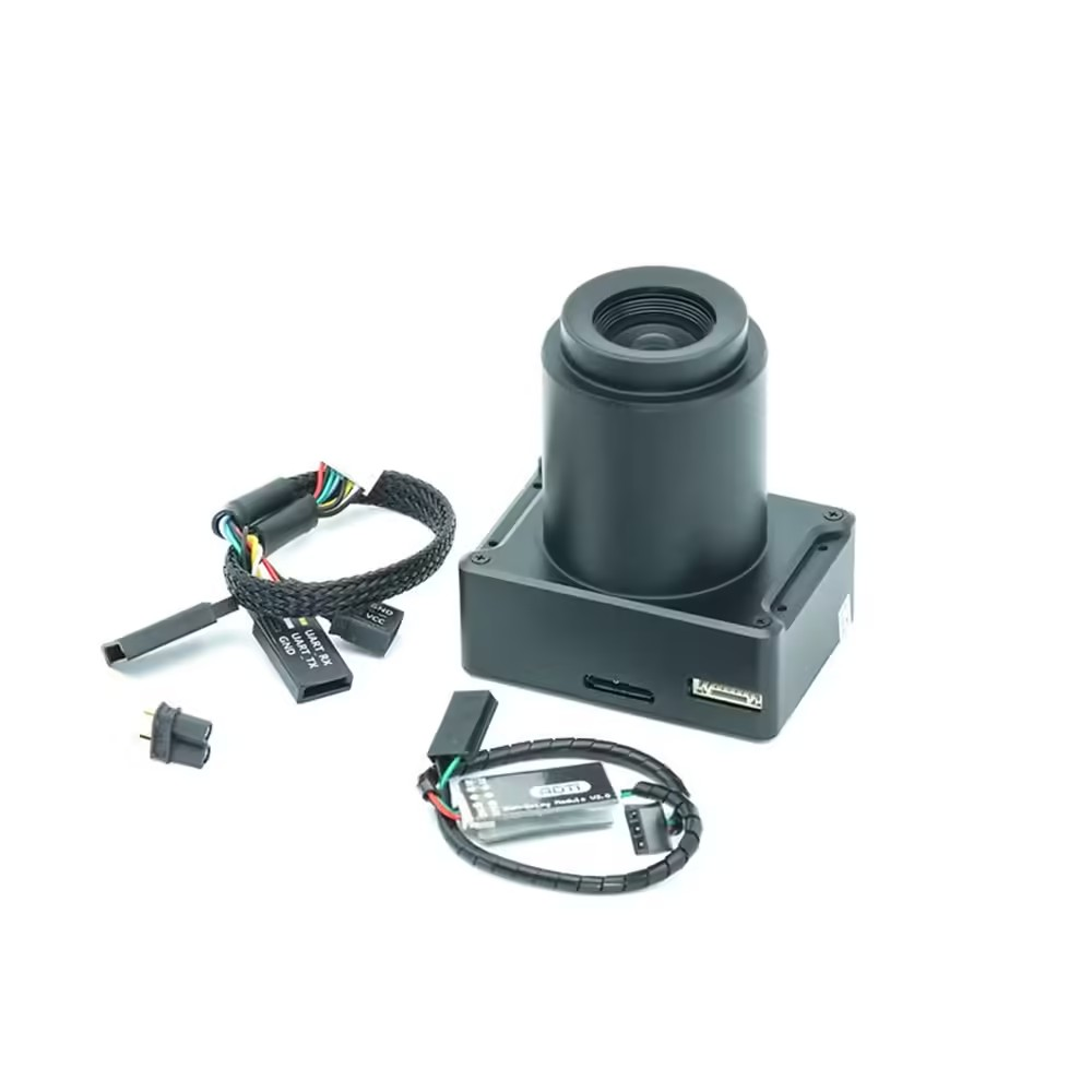
Introducing the ADTi 26MP 26S V1 Surveyor Drone Camera, a compact and high-performance device designed for mapping. The unique selling point of this camera is its incorporation of the latest mapping technology. The advanced 26MP APS-C sensor ensures exceptional image quality and precision, making the ADTi 26S V1 an outstanding choice for professional mapping and surveying applications.
ADTi 26MP 26S V1 Surveyor Drone Camera: Features That Are Important
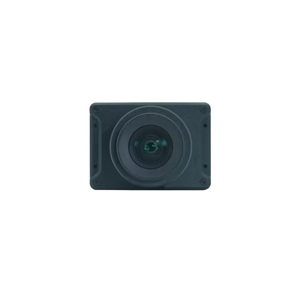
Compact Design: The ADTi 26S V1 Surveyor Camera for Drones boasts a diminutive size of just 5.8 x 5.8 x 2.3 cm and a light weight of 120 g, making it one of the most compact and lightweight mapping cameras on the market. Its small footprint ensures a minimal impact on your drone’s payload and allows for seamless integration with various drone platforms, rendering it an adaptable option for diverse surveying tasks.
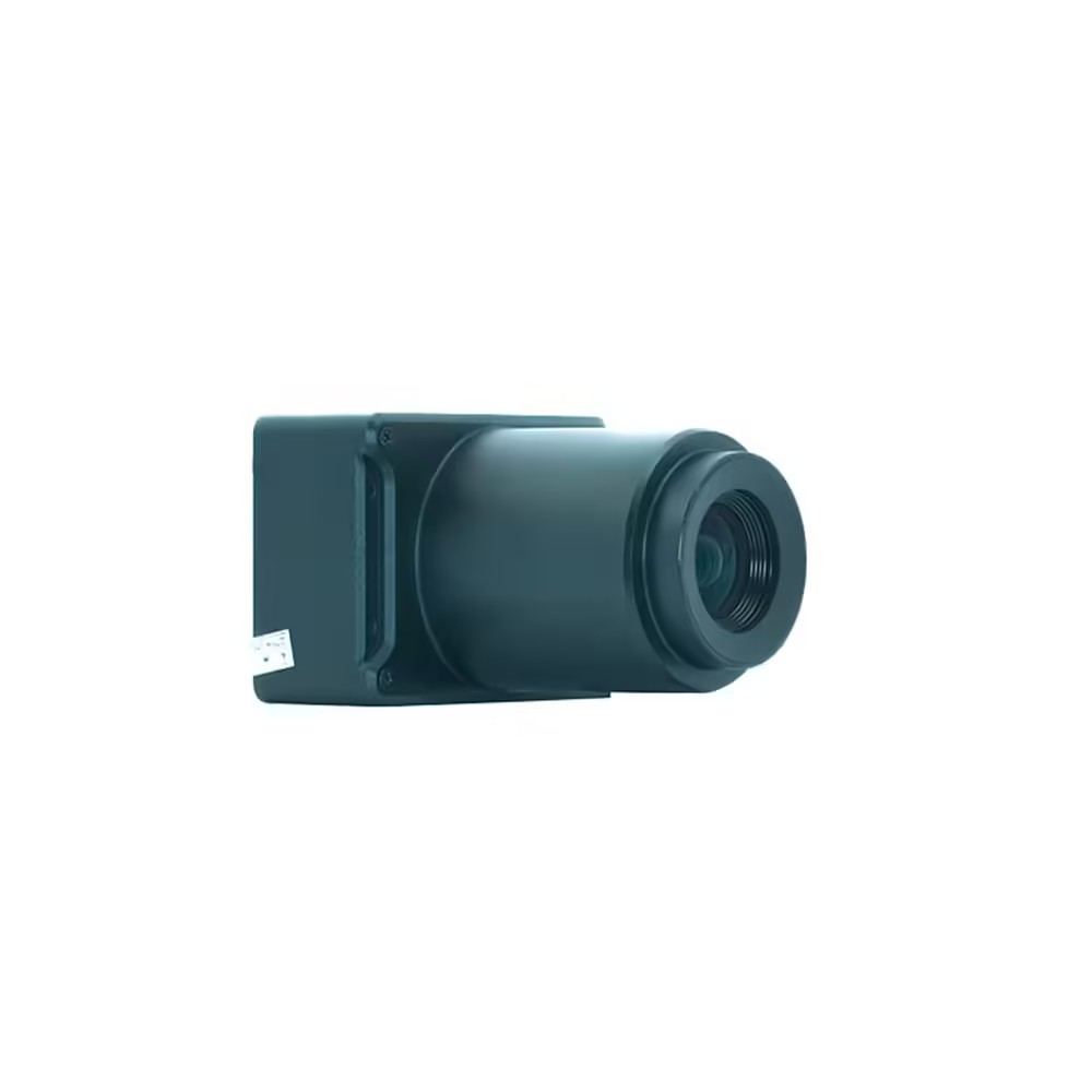
High-Resolution Imaging: Featuring a Sony IMX571 CMOS sensor and a Socionext Imaging processor-Milbeaut®, the 26MP ADTi 26S V1 Surveyor Drone Camera is capable of capturing exceptionally detailed images with 26.1 megapixels resolution, low heat generation, and superb color accuracy. The high-resolution sensor ensures every nuance is recorded with precision, making these cameras ideal for applications that demand detailed orthomosaics, 3D models, and precise topographic mapping.
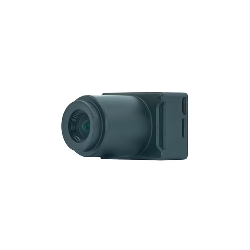
Versatile Lens Options: Choose from two fixed lenses to match your mapping needs:
- 25mm Lens: Offers a 59° field of view (FOV) with a 37.5mm equivalent focal length and minimal distortion (<0.5%).
- 35mm Lens: Provides a 45° FOV with a 52mm equivalent focal length and extremely low distortion (<0.02%).
Advanced Imaging Technology: The ADTi Surveyor Drone Camera 26MP 26S V1 boasts a mechanical shutter and fixed focus lenses, ensuring consistently sharp, high-quality images. It also features a built-in Multi-Interface hot shoe output for precise PPK geotagging, with an optional direct geotagging function. This cutting-edge technology renders the ADTi 26S V1 26MP Drone Mapping Camera a superior selection for professionals who require high precision in geospatial data.
Robust Build: Crafted with a full aluminum structure, the ADTi 26MP 26S V1 Surveyor Drone Camera is built to endure the demands of fieldwork, offering both durability and reliability. Its sturdy construction guarantees performance in the challenging conditions typically faced in surveying environments, ensuring dependable operation in any situation.
ADTi 26MP 26S V1 Surveyor Drone Camera: Image And Video Specifications
- Image Resolutions: 6192 x 4128 (26 MP), 4800 x 3200 (15.4 MP), 3680 x 2456 (9.0 MP), and 2400 x 1600 (3.8 MP).
- Video Resolutions: 1920×1080 (60p), 640×480 (30p).
- Image File Format: JPEG.
- Video File Format: MP4.
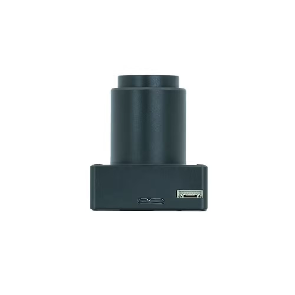
- HD Video Out: Yes, with an HDMI connection.
Operating Conditions: The Mapping Cameras for the ADTi 26MP 26S V1 Drone are designed to function efficiently within a temperature range of -10 to 40°C and are powered by a 12-24V DC LiPo or Li-ion battery. This wide operating range ensures the camera’s usability in diverse environmental conditions, making it ideal for both extreme cold and heat.
Dimensions and Weight: The ADTi 26MP 26S V1 Drone Surveying Camera has dimensions of 5.8 x 5.8 x 2.3 cm and a weight of 71g without the case, or 122g with the aluminum case. Packaged in a 14.5 x 10 x 6 cm box with a total weight of 500g, its compact and lightweight design facilitates easy transportation and handling, ensuring convenience during field operations.
Enhanced Connectivity: Featuring multiple connectivity options, the ADTi 26MP 26S V1 Surveyor Drone Camera includes a built-in HDMI port for real-time video output and a USB port for rapid data transfer. These connectivity features allow for smooth integration with ground control stations and other surveying equipment, thereby enhancing workflow efficiency.
User-Friendly Interface: The 26MP ADTi 26S V1 Drone Camera for Mapping offers an intuitive user interface, simplifying the configuration of settings and operation of the camera. This user-friendly interface is tailored to streamline the surveying process, minimize the learning curve, and allow users to concentrate on data collection.
Versatile Application: The ADTi 26MP 26S V1 extends beyond conventional surveying tasks. With its high-resolution imaging and sturdy construction, it is well-suited for a variety of applications, including agriculture, environmental monitoring, and infrastructure inspection, demonstrating its adaptability to meet a wide range of industrial requirements.
ADTi 26MP 26S V1 Surveyor Drone Camera
ADTi 26MP 26S V1 Surveyor Drone Camera combines the latest technology with a compact design. To provide superior performance for drone-based mapping and surveying. Enhance your aerial data collection task today. Buy and start using this best mapping ADTi Surveyor Drone Camera 26MP 26S V1. This camera is engineered for precision in various surveying applications. You might be into mapping agricultural fields, monitoring environmental changes, or inspecting infrastructure. Choose and buy this product today. This ADTi 26MP 26S V1 delivers the accuracy and detail you need to make informed decisions.
Package Include.
1 X ADTi 26MP 26S V1 Surveyor Drone Mapping Cameras.
ADTi 26MP 26S V1 Surveyor Drone Mapping Cameras Overview
The ADTi 26MP 26S V1 Surveyor Drone Camera is a compact mapping camera designed for professional aerial surveying and mapping tasks. Featuring a high-performance 26MP APS-C sensor, it delivers precise, high-resolution imagery and HD video outputs tailored for accurate terrain analysis.
Key Features of ADTi 26MP 26S V1 Surveyor Drone Mapping Cameras
- 26MP APS-C sensor offering 6192×4128 pixel images for detailed mapping projects
- Four selectable image resolutions: 6192×4128, 4800×3200, 3680×2456, and 2400×1600
- HD video capture at 1920×1080 (60p) and low-resolution 640×480 (30p) in MP4 format
- Onboard HDMI port for live HD video output to ground stations or monitors
- Compact form factor (5.8×5.8×2.3 cm) and lightweight (120 g) to minimize drone payload impact
- Images saved in JPEG format for fast post-flight processing and analysis
- Genuine product with fast shipping from Zbotic for prompt field deployment
Applications and Use Cases
- Agricultural land mapping to monitor crop health and optimize field management
- Construction site surveying for progress tracking and volume calculations
- Topographic and cadastral mapping for urban planning and land parceling
- Environmental and forestry surveys to assess vegetation density and terrain changes
- Archaeological site documentation requiring high-resolution orthophotos
How to Use ADTi 26MP 26S V1 Surveyor Drone Mapping Cameras
Mount the ADTi 26S V1 onto a compatible drone gimbal, secure the HDMI cable to your ground monitor, and power on the camera. Select your desired image or video resolution via the onboard controls, perform a brief calibration if needed, and initiate recording through your flight controller. After flight, transfer JPEG and MP4 files to your workstation for mapping software integration.
Why Buy from Zbotic?
- Genuine Products: All items sourced from authorized distributors
- Fast Shipping: Orders ship within 24 hours with tracking (non backordered products)
- Free Shipping: Free delivery on qualifying orders
- COD Available: Cash on Delivery, UPI, cards, net banking
- Technical Support: Expert help for setup and troubleshooting
- Easy Returns: Hassle-free replacement for defective products
Frequently Asked Questions
What image formats and resolutions can I capture?
The camera captures JPEG images at four resolutions: 6192×4128 (26 MP), 4800×3200 (15.4 MP), 3680×2456 (9 MP), and 2400×1600 (3.8 MP).
How do I monitor live video during flight?
Use the onboard HDMI output to connect the camera directly to any HDMI-compatible ground monitor or video transmitter for real-time HD (1920×1080 60p) preview.
Is the ADTi 26S V1 compatible with standard drone gimbals?
Yes, its compact dimensions (5.8×5.8×2.3 cm) and 120 g weight make it compatible with most third-party and custom drone gimbal mounts designed for mapping cameras.

DJI O3 Air Unit Review: Best FPV Video Transmission for India Builders
DJI O3 Air Unit Review: Best FPV Video Transmission for India Builders When DJI launched the O3 Air...
Read More →
Drone Racing League: Start Competing in India
Table of Contents Understanding Drone Racing League Key Components and Requirements Step-by-Step Setup Guide Configuration and Optimisation Practical...
Read More →
Drone Return to Home (RTH): Setup, Modes & Troubleshooting
Drone Return to Home (RTH): Setup, Modes & Troubleshooting Return to Home (RTH) is arguably the most important...
Read More →Technical Specifications
| Brand | ADTi |
|---|---|
| SKU | AI6066 |
| Availability | In Stock |
Applications & Use Cases
The ADTi 26MP 26S V1 Surveyor Drone Mapping Cameras is a versatile drone gimbal and accessories used across a wide range of applications including electronics projects, DIY builds, prototyping, and educational experiments.
Common use cases:
- Integrating into a custom electronics project
- Learning and experimenting with circuits
- Replacing or upgrading components in existing setups
This product is ideal for electronics enthusiasts, engineers, and students.
Technical Tip: Always verify voltage and current requirements before connecting to your circuit. Check datasheets for detailed specifications and pin configurations.
Shipping & Delivery
- Free shipping on orders above ₹999 across India
- Dispatched within 1-3 business days
- Expected delivery: 3-7 business days depending on location
- Secure packaging to ensure safe transit of electronic components
- Genuine ADTi product sourced from authorized channels


Vansh Parekh (verified owner) –
Decent ADTi 26MP 26S V1 Surveyor Drone for the price. Using it in my quadcopter, performs well overall.
Pranav Khanna (verified owner) –
This ADTi 26MP 26S V1 Surveyor Drone is exactly what I needed for my drone. Works perfectly, very reliable.
Devansh Chatterjee (verified owner) –
Top quality ADTi 26MP 26S V1 Surveyor Drone. I’m a regular customer of Zbotic and they never disappoint.
Naman Sharma (verified owner) –
Excellent product for the price. My drone flies smoothly with this ADTi 26MP 26S V1 Surveyor Drone. Highly recommended!
Swati Gupta (verified owner) –
My 5th order from Zbotic. This ADTi 26MP 26S V1 Surveyor Drone is excellent as always. Totally reliable store.
Ajay Dhawan (verified owner) –
Good quality ADTi 26MP 26S V1 Surveyor Drone. Minor scratches on arrival but functionally perfect.
Paras Bose (verified owner) –
Decent ADTi 26MP 26S V1 Surveyor Drone. Took some effort to set up but working now.
Lokesh Vohra (verified owner) –
Good quality ADTi 26MP 26S V1 Surveyor Drone. Minor scratches on arrival but functionally perfect.
Sandeep Grewal (verified owner) –
Perfect for my agriculture drone project. This ADTi 26MP 26S V1 Surveyor Drone handles the weight effortlessly.
Deepika Khurana (verified owner) –
Amazing build quality! This ADTi 26MP 26S V1 Surveyor Drone is sturdy and lightweight at the same time.
Urmi Shah (verified owner) –
Using this ADTi 26MP 26S V1 Surveyor Drone in my hexacopter. Smooth operation and excellent thrust.
Harsh Khanna (verified owner) –
Top quality ADTi 26MP 26S V1 Surveyor Drone. I’m a regular customer of Zbotic and they never disappoint.
Hitesh Kulkarni (verified owner) –
Good ADTi 26MP 26S V1 Surveyor Drone. Works well for my drone build. Packaging could be slightly better.
Chirag Saini (verified owner) –
Solid ADTi 26MP 26S V1 Surveyor Drone. Not the absolute best but excellent value for the price point.
Zara Kumar (verified owner) –
Been using this ADTi 26MP 26S V1 Surveyor Drone for 3 months now, zero issues. Great product.