
Table of Contents
- Introduction
- What Is Drone Obstacle Avoidance?
- Optical Flow Sensors: How They Work
- Lidar Sensors for Drones
- Optical Flow vs Lidar: Which One Do You Need?
- Integrating Sensors with Flight Controllers
- Real-World Use Cases in India
- Build Tips and Best Practices
- Recommended Products
- Frequently Asked Questions
- Conclusion
Introduction
India’s drone industry is booming. From precision agriculture in Maharashtra’s sugarcane fields to surveillance missions along our vast coastlines, drones are becoming indispensable tools across industries. But with increased autonomy comes a critical challenge — how does a drone avoid crashing into trees, power lines, buildings, or other obstacles without a human pilot constantly watching?
The answer lies in obstacle avoidance systems — a combination of smart sensors, algorithms, and flight controller integration that allow drones to detect and respond to hazards in real time. In this comprehensive guide, we’ll explore two of the most important technologies powering modern obstacle avoidance: optical flow sensors and lidar sensors. We’ll explain how each works, when to use each technology, and how to integrate them into your drone build.
Whether you’re building an agricultural spraying drone for the Kharif season or designing a surveillance platform for smart city deployments, understanding obstacle avoidance will elevate your builds from hobby projects to professional-grade systems.
What Is Drone Obstacle Avoidance?
Obstacle avoidance is the ability of a drone to detect objects in its flight path and autonomously manoeuvre around them — or halt before collision — without direct pilot input. It’s a multi-layered challenge that involves sensor data acquisition, real-time processing, and dynamic flight path correction.
There are several approaches to obstacle avoidance:
- Reactive avoidance: The drone detects an obstacle and immediately alters course or brakes. Simple and fast but limited in complex environments.
- Path planning: Before or during flight, the drone maps its environment and calculates collision-free routes. Used in autonomous mission planning.
- SLAM (Simultaneous Localisation and Mapping): The drone builds a map of its surroundings in real time while tracking its own position within that map. Used in advanced indoor navigation.
The sensors that feed data into these systems include cameras, ultrasonic sensors, infrared sensors, optical flow sensors, and lidar. Each has distinct strengths and limitations, and understanding them is key to building a reliable system.
In India, obstacle avoidance is particularly critical for agricultural drones operating in cluttered environments — think mango orchards in Andhra Pradesh or areca nut plantations in Karnataka — where tree canopies, irrigation pipes, and power lines create dense obstacle fields. Similarly, surveillance drones in urban India must navigate between buildings, telephone cables, and crowded airspace.
Optical Flow Sensors: How They Work
An optical flow sensor is essentially a downward-facing camera (sometimes infrared) that continuously captures images of the ground below the drone. By comparing consecutive frames, it calculates the apparent motion of surface features — much like how a computer mouse tracks movement on a desk surface.
The Physics Behind Optical Flow
Optical flow works on a simple principle: if the drone moves horizontally, ground features appear to shift in the opposite direction in the camera image. The rate and direction of this apparent shift — the optical flow vector — directly corresponds to the drone’s velocity over the ground.
The mathematical relationship is:
Velocity = (Pixel displacement × Altitude) / (Focal length × Time interval)
This means optical flow sensors are altitude-dependent — they need to know the drone’s height above ground to convert pixel displacement into actual speed. That’s why optical flow systems are almost always paired with an ultrasonic or lidar rangefinder that provides altitude data.
Key Specifications to Understand
- Resolution: Higher resolution sensors detect finer ground texture, improving low-light and high-altitude performance.
- Frame rate: Faster frame rates allow accurate tracking at higher drone speeds. Look for 400fps or above for racing or fast autonomous drones.
- Field of view (FOV): Wider FOV captures more ground area per frame but reduces effective resolution.
- Minimum altitude: Most optical flow sensors need at least 30–50cm altitude to work reliably. Below this, ground features move too fast across the frame.
- Maximum altitude: Typically limited to 3–8 metres without a rangefinder assist. With lidar, effective range extends to 30–50 metres.
Popular Optical Flow Sensors
The PX4FLOW is one of the most widely used optical flow modules in the DIY drone community. It includes a ADNS-3080 or MT9V034 image sensor, an ultrasonic rangefinder, and a gyroscope for motion compensation. It connects to Pixhawk and ArduPilot-based flight controllers via I2C or UART.
The Matek OPTICAL FLOW & LIDAR Sensor 3901-L0X combines optical flow with a VL53L0X lidar rangefinder in a compact module, making it excellent for indoor drones and small racing quads.
Limitations of Optical Flow
Optical flow sensors struggle in certain conditions common in Indian deployments:
- Featureless terrain: Optical flow fails over water bodies, sandy deserts, or uniform concrete surfaces where there are no distinct features to track.
- Low light: Night operations or flying over dark terrain degrade performance significantly.
- High-altitude flight: Above 10 metres, ground features become too small to track reliably without a high-resolution sensor.
- Forward obstacle detection: Optical flow is typically downward-facing and provides position hold assistance, not forward obstacle detection.
Lidar Sensors for Drones
Lidar (Light Detection and Ranging) works by emitting pulses of laser light and measuring the time it takes for the light to reflect back from a surface. Since light travels at a known speed (~3×10⁸ m/s), the round-trip time directly gives the distance to the object.
Distance = (Speed of light × Time of flight) / 2
Types of Lidar Used in Drones
1D Lidar (Rangefinders): These emit a single laser beam, measuring distance in one direction. They’re lightweight (often under 10g), inexpensive, and commonly used as downward-facing altimeters. Examples include the Garmin LIDAR-Lite, Benewake TF02-Pro, and TF-Luna. In ArduPilot, these are configured as rangefinders and improve altitude hold accuracy significantly.
2D Lidar (Scanning Lidar): These rotate a single laser or use multiple beams to build a 2D map of the surroundings in a plane. The RPLidar A1/A2/A3 series are popular examples. Used for obstacle avoidance in a horizontal plane, they’re excellent for indoor drones and ground robots but add significant weight and complexity.
3D Lidar: These use multiple beams at different vertical angles to create a full 3D point cloud of the environment. Examples include the Velodyne VLP-16 (16-beam) and the cheaper Livox Mid-40. They’re used in professional surveying drones, delivery drones, and advanced SLAM systems. Weight and cost are significantly higher — typically starting from ₹50,000 and going up to several lakhs.
Lidar Advantages for Indian Conditions
Unlike optical flow sensors, lidar works regardless of terrain texture, lighting conditions, or altitude. For agricultural drones operating over paddy fields in Bihar or cotton fields in Telangana — where terrain can be uniformly textured — lidar is far more reliable. Key advantages include:
- Works at night: Laser-based, so unaffected by ambient light levels.
- Terrain following: 1D lidar can maintain constant altitude above crop canopy, improving spraying efficiency in undulating terrain.
- Indoor GPS-denied navigation: 2D lidar enables SLAM-based navigation where GPS signals are unavailable or unreliable.
- Precise altitude control: Accuracy of ±2–5cm, far better than barometric altimeters (which drift due to pressure changes from props).
Lidar Limitations
- Glass and mirrors: Laser light passes through glass or reflects unpredictably off mirrors. Glass facades in urban environments can cause false readings.
- Rain and dust: Heavy monsoon rain or dusty conditions in Rajasthan can scatter laser pulses, reducing effective range.
- Power consumption: 3D lidar systems draw significant current, reducing flight time.
- Cost: Quality lidar modules are significantly more expensive than optical flow sensors.
Optical Flow vs Lidar: Which One Do You Need?
The choice between optical flow and lidar depends heavily on your use case, environment, and budget. Here’s a practical comparison for Indian drone builders:
| Parameter | Optical Flow | Lidar |
|---|---|---|
| Cost | ₹800–₹3,000 | ₹2,500–₹5,00,000+ |
| Best Use | Indoor hover, low-altitude position hold | Terrain following, altitude accuracy, SLAM |
| Lighting | Needs adequate light | Day and night |
| Terrain type | Textured surfaces only | Any surface |
| Weight | 10–30g | 5g (1D) to 900g (3D) |
| Integration difficulty | Moderate | Low (1D) to High (3D) |
For agricultural drones: A combination of 1D lidar (downward rangefinder for terrain following) plus GPS is most practical and cost-effective. Add optical flow only if you need precision hover near obstacles without GPS.
For indoor inspection drones: 2D scanning lidar or optical flow (with rangefinder assist) are your primary tools. 2D lidar gives you the full picture for SLAM navigation.
For racing/FPV drones: Neither optical flow nor lidar is typically used — speed and pilot reaction are the obstacle avoidance system!
For surveillance drones: 1D lidar for altitude control paired with GPS and optical flow for hover stability gives excellent results at reasonable cost.
Integrating Sensors with Flight Controllers
ArduPilot / Pixhawk Integration
ArduPilot (used in Pixhawk, Cube Orange, Matek H743, etc.) has excellent built-in support for both optical flow and lidar sensors. Here’s how to set up each:
Optical Flow Setup in ArduPilot
- Connect the optical flow sensor to the Pixhawk’s I2C port (for PX4FLOW) or serial port.
- Set
FLOW_TYPEto the appropriate value (1 for PX4FLOW, 5 for Cheerson CX-OF, 6 for CXOF, etc.). - Set
FLOW_ORIENT_YAWto match the sensor’s physical orientation relative to the drone’s forward direction. - Enable
FLOW_ENABLE = 1. - Configure the paired rangefinder using
RNGFND1_TYPE,RNGFND1_MIN_CM, andRNGFND1_MAX_CM. - Calibrate using the optical flow loiter test: hover at 1 metre with no GPS, engage LOITER mode, and verify the drone holds position.
Lidar Rangefinder Setup in ArduPilot
- Connect via serial (UART) or I2C depending on the module.
- Set
RNGFND1_TYPEto match your lidar model (20 for Benewake TFMini, 27 for TF02, etc.). - Set
RNGFND1_ORIENTto 25 (downward-facing) for altitude measurement. - Set
RNGFND1_MIN_CMandRNGFND1_MAX_CMper the sensor’s spec sheet. - Enable terrain following with
TERRAIN_ENABLE = 1and relevant terrain data.
Proximity Sensors for Obstacle Avoidance
ArduPilot’s Proximity library allows forward/lateral obstacle avoidance using lidar or ultrasonic sensors. Set PRX1_TYPE for the proximity sensor and configure avoidance behaviour with AVOID_ENABLE, AVOID_DIST_MAX, and AVOID_MARGIN parameters.
Betaflight Integration
Betaflight has limited obstacle avoidance support — primarily optical flow for position hold in the ANGLE/HORIZON modes. Connect the sensor via UART, enable the optical flow feature in the Betaflight Configurator under Configuration → Features, and configure in the Sensors tab.
Real-World Use Cases in India
1. Agricultural Spraying Drones
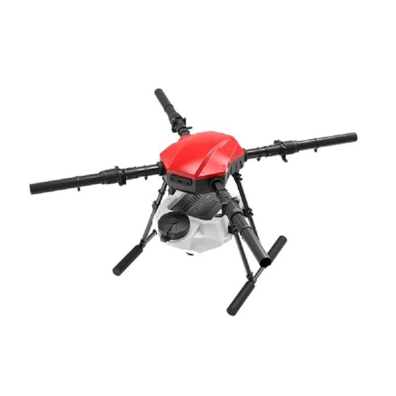
Agricultural drones in India spray pesticides and fertilisers over fields. EFT’s 10L and 16L frames are popular platforms for this application. These drones need terrain-following capability — maintaining a constant 1.5–2 metre height above the crop canopy regardless of field elevation changes. A downward-facing 1D lidar like the Benewake TF02 Pro excels here, feeding real-time altitude data to the flight controller.
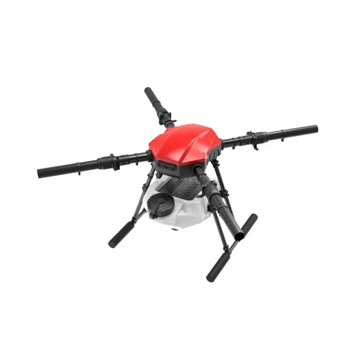
EFT E410P 10L 4 Axis Agricultural Drone Frame
A rugged 4-axis agricultural drone frame designed for 10-litre spray tanks. Compatible with lidar and optical flow sensors for precision terrain-following operations over Indian farmland.
EFT E416P 16L 4 Axis Agricultural Drone Frame
Heavy-duty 16-litre payload agricultural frame with fold-arm design for easy transport. Ideal for large-scale precision farming with integrated sensor bays for lidar modules.
2. Surveillance and Security Drones
The EFT 6120 Multifunction Surveillance Drone Frame is designed for extended endurance surveillance missions. Adding optical flow ensures stable hover for clear image capture, while forward-facing lidar prevents collisions during autonomous patrol routes.
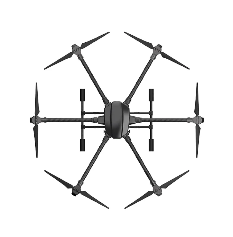
EFT 6120 Multifunction Surveillance Drone Frame
A professional 6-arm hexacopter frame built for surveillance and inspection missions. Features dedicated sensor mounting points and is fully compatible with Pixhawk flight controllers for lidar integration.
3. Indoor Inspection Drones
Industrial facilities — steel plants, power stations, warehouses — increasingly use indoor drones for inspection. GPS is unavailable indoors, making optical flow and 2D lidar the primary navigation technologies. A lightweight quadcopter with PX4FLOW + RPLidar can autonomously navigate factory floors, reading equipment status without human entry into hazardous zones.
Build Tips and Best Practices
Mechanical Placement
- Optical flow sensor: Mount at the exact centre of gravity of the drone, directly downward-facing. Any tilt induces error. Use vibration-damping foam or standoffs — prop vibration is the number-one cause of optical flow noise.
- Downward lidar: Mount at the lowest point of the drone (below the landing gear if possible) to get clean reflections. Avoid mounting where prop wash or landing gear could partially obstruct the beam.
- Forward lidar: Mount at the front, level with the drone’s horizon. Keep it away from power cables and high-EMI components.
Vibration Management
Vibration is the enemy of optical flow sensors. Carbon fibre frames transmit vibration efficiently, so always use vibration-damping mounts. The Anti-Vibration Shock Absorber for Pixhawk is essential for any sensor-heavy build.
Anti-Vibration Shock Absorber for APM/KK/MWC/PixHawk
Dedicated vibration isolation mount for flight controllers and sensitive sensors. Reduces high-frequency prop vibrations that degrade optical flow and IMU accuracy.
GPS Quality and Sensor Fusion
Obstacle avoidance systems work best with sensor fusion — combining GPS, optical flow, lidar, and IMU data to produce a robust position estimate. ArduPilot’s EKF3 handles this fusion automatically when sensors are correctly configured. Investing in a high-gain GPS antenna significantly improves position hold, which reduces the demand on optical flow sensors.
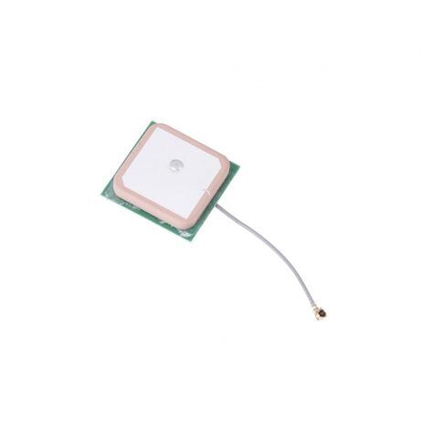
25x25x8mm 28dB High Gain Active GPS Antenna
High-gain ceramic active GPS antenna for NEO-6M, NEO-7M, and NEO-8M modules. Provides stronger satellite lock in challenging Indian environments including urban canyons and farm areas.
Propeller Balance
Balanced propellers dramatically reduce vibration levels, improving the performance of every sensor on the drone. Carbon fibre propellers are stiffer and lighter than plastic, reducing flex-induced vibration. Always balance each propeller statically and dynamically before flying a sensor-equipped drone.
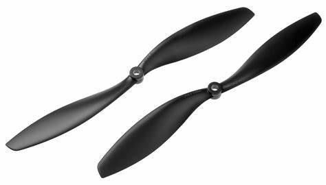
1045 Carbon Fiber Propeller CW&CCW Set
Lightweight stiff carbon fibre propellers that minimize vibration transfer to the frame. Ideal for sensor-equipped drones where IMU and optical flow accuracy is critical.
Frequently Asked Questions
Can I use optical flow without GPS?
Yes! Optical flow is specifically designed for GPS-denied environments. ArduPilot’s FLOWHOLD mode uses optical flow as the sole horizontal position reference. You will need a paired rangefinder (lidar or ultrasonic) for altitude measurement. This combination enables stable indoor hover without any GPS signal.
What is the maximum range of obstacle avoidance lidar?
It depends on the lidar type. 1D rangefinders like the Benewake TF02 Pro have a range of 22 metres. The TFMini Plus reaches 12 metres. 2D scanning lidar like the RPLidar A3 scans up to 25 metres. For agricultural terrain following, 10–20 metres of range is sufficient. For collision avoidance in high-speed flight, you want at least 15–20 metres to allow adequate reaction time.
Does ArduPilot support 3D obstacle avoidance?
ArduPilot’s Proximity library supports multi-sector obstacle avoidance with up to 8 distance sensors in different directions. For true 3D avoidance, you need multiple rangefinders or a 3D lidar plus the AVOID_ENABLE parameter set appropriately. Full 3D SLAM requires external processing, typically on a companion computer running ROS.
Is DGCA approval needed for obstacle avoidance sensors in India?
The sensors themselves don’t require separate approval, but the drone that carries them must comply with DGCA regulations. Drones above 250g operating in controlled airspace require UIN registration and UAOP as applicable. Always check the latest DGCA Digital Sky platform guidelines before deploying autonomous drones commercially.
Which is better — ultrasonic or lidar for downward ranging?
Lidar is significantly better for drone applications. Ultrasonic sensors are affected by the acoustic noise from propellers, which can cause false readings. They also have slower update rates and are less accurate. Lidar is immune to acoustic noise, faster (up to 1000Hz update rate), and more accurate (±2cm vs ±1–3cm for ultrasonics, but ultrasonic accuracy degrades significantly in noisy environments).
Conclusion
Obstacle avoidance is not a luxury — it’s becoming an essential feature for professional drone operations in India. Whether you’re building agricultural drones that need to skim above crop canopy at precise heights, surveillance platforms that patrol autonomously around buildings, or indoor inspection drones that navigate GPS-denied environments, optical flow and lidar sensors are your primary tools.
Optical flow excels in low-altitude, textured-terrain environments where you need stable hover without GPS. Lidar excels in terrain following, precise altitude measurement, and all-conditions operation. In most professional builds, using both together — optical flow for position hold and lidar for altitude — gives the best results.
The good news for Indian builders is that 1D lidar rangefinders and optical flow modules have come down dramatically in price, making professional-grade obstacle avoidance accessible even at ₹3,000–₹8,000 for the sensor combination. The investment in reliability, safety, and mission capability far outweighs the cost.
Ready to build your obstacle-avoiding drone? Explore Zbotic’s full range of drone components — from high-quality frames to flight controllers and GPS modules — all sourced specifically for Indian builders.


Add comment